

St Ricarius Church
Wikimedia Commons
Aberford is a rural village Small rural collection of buildings with a church. and civil parish
 Smallest administrative unit in England. near the eastern boundary of the City of Leeds in West Yorkshire, a historic settlement in the ancient Kingdom of Elmet. The village developed along the old Great North Road where it crosses the the Cock Beck.
The old Great North Road was turnpiked in 1799 and the village became a coaching stop. The Gascoignes of neighbouring Parlington Hall were influential in the village. They employed workers in their limestone quarries and collieries. They built the landmark almshouses and a mineral and passenger railway that linked the village to their collieries and the railway station at Garforth.
The A1 bypass was built around Aberford in 1932, leaving the village a quiet rural backwater.
Geography

Wikimedia Commons
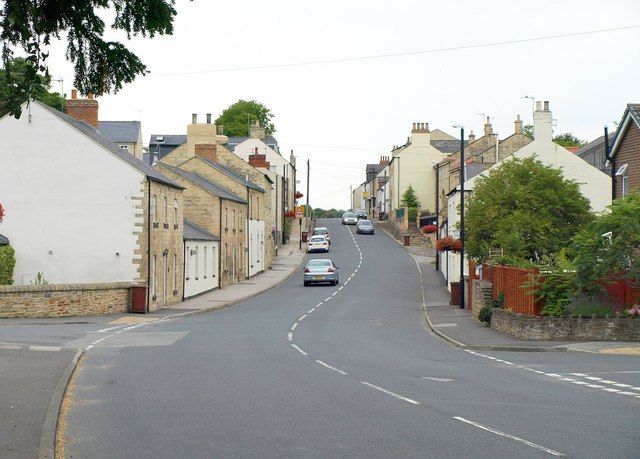
Aberford is a linear village stretched north to south along the old Great North Road that followed the course of the earlier Roman road and an even earlier Celtic track. The road passes over Cock Beck, which flows west to east in its shallow valley through the village. The landscape is undulating, generally about 50 metres (164 ft) above sea level, with areas of woodland and open agricultural land.[1]
The A1(M) motorway bypasses the village along its eastern side, parallel to the old Great North Road. It is joined by the M1 after Junction 47 (Parlington Interchange) and to the north is Junction 44 (Bramham Crossroads) with the A64 Leeds to York road.
Aberford is east of the boundary between the exposed Lower Coal Measures that were worked at Parlington Hollins and the Permian magnesian limestone that was quarried along its outcrop for building stone.[2] Many buildings in the village are built of local limestone.[3]
History
The scheduled monuments of Aberford Dykes are long earthworks running east-west to the north of the village, of uncertain date. Excavations of a section of the South Dyke in 1996–1967 and 2007 indicate that it may have been built in the late Iron Age or early Roman period as a territorial or defensive boundary. The other Aberford Dykes face north, and are possibly defensive boundaries for the post-Roman Kingdom of Elmet.[5]
Wikimedia Commons
Main Street follows the line of Ermine Street, a Roman road that connected settlements at Castleford and Aldborough. It is thought that Aberford House was built on the site of a Roman fort.[6]
Aberford is named from an Anglo Saxon female name, Eadburh, and ford,[7] marking the place where the road crossed the Cock Beck; Ædburford was mentioned in the Pipe Rolls in 1176. Cock Beck powered two corn mills, and the field names Limekiln Flatt and Little Limestone Flatt on the 1847 tithe map indicate a possible site for lime kilns.[8]
Wikimedia Commons
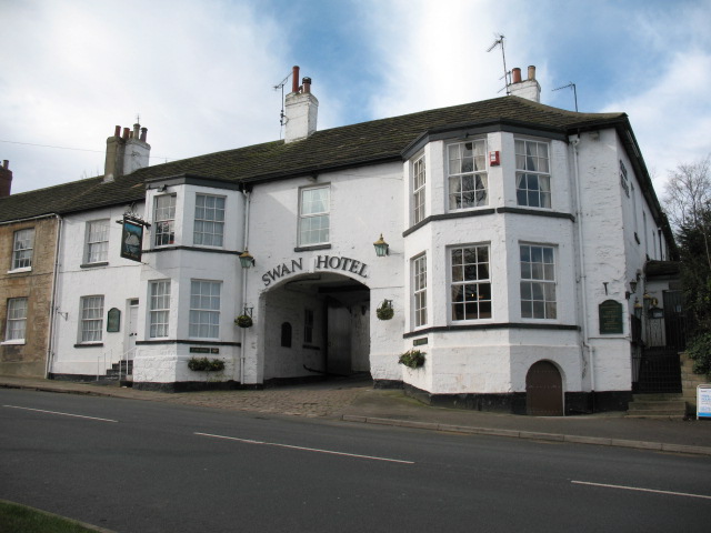
The manufacture of pins for domestic use and hackle pins for wool combing and dressing flax was established in the 17th century.[8] At the end of the 18th century the old Roman road through the village was the Ferrybridge and Boroughbridge turnpike road, and Aberford became a coaching stop. A toll house was built at the northern end of the village, and milestones were erected along the main road. The Swan Hotel is an 18th-century coaching inn, with a large central archway accessing its yard and stables.[9]
The Gascoignes of neighbouring Lotherton Hall and Parlington Hall, had a huge influence on village life in the 18th and 19th centuries. They built estate lodges and the Hookmoor Lodges, possibly designed by the architect John Carr Prolific architect who worked mainly in the North of England, (1723–1807). in about 1800. They also funded the library and reading room in 1843, and built the Gothic-inspired almshouses 1843–1845. The Gascoignes were employers at limestone quarries and collieries on their estate, and in 1835 built the Aberford Railway, the Fly Line, to transport coal from Garforth to the coal depot at the end of Parlington Lane, next to the turnpike road. A passenger service also operated for a time. The line closed in 1924.[9]
Aberford’s importance continued until the construction of the A1 bypass in 1962, which removed through-traffic from the village. Today Aberford is a rural residential village, and its population growth is a result of housing developments.[9]
Religion and education
The church, the only one in Britain dedicated to Saint Ricarius French monk (c. 560 – c. 645) venerated as a saint by the Catholic Church, who spent some time in England attempting to ransom French prisoners., is built in local limestone, and is possibly of pre-Conquest origin. Fragments of the 12th-century church survive in the lower part of the tower, and in a reset window in the north chancel
 Part of a church containing the altar, used by the officiating clergy. wall after it was substantially rebuilt in 1861.[8]
A school, founded by Lady Elizabeth Hastings in 1716 in the tithe barn behind the church, became a national school Schools set up by Anglican clergy and their local supporters, initially run by single teachers using the monitorial system. in 1817, and is now Aberford C of E Primary School.[10]

