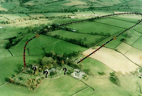

Probable extent of the outer ditch
British Archaeology
Mellor hill fort is a prehistoric site in North West England dating from the British Iron Age, which lasted from about 800 BCE to 100 AD. Situated on a hill in the village of Mellor, Greater Manchester, on the western edge of the Peak District, it overlooks the Cheshire Plain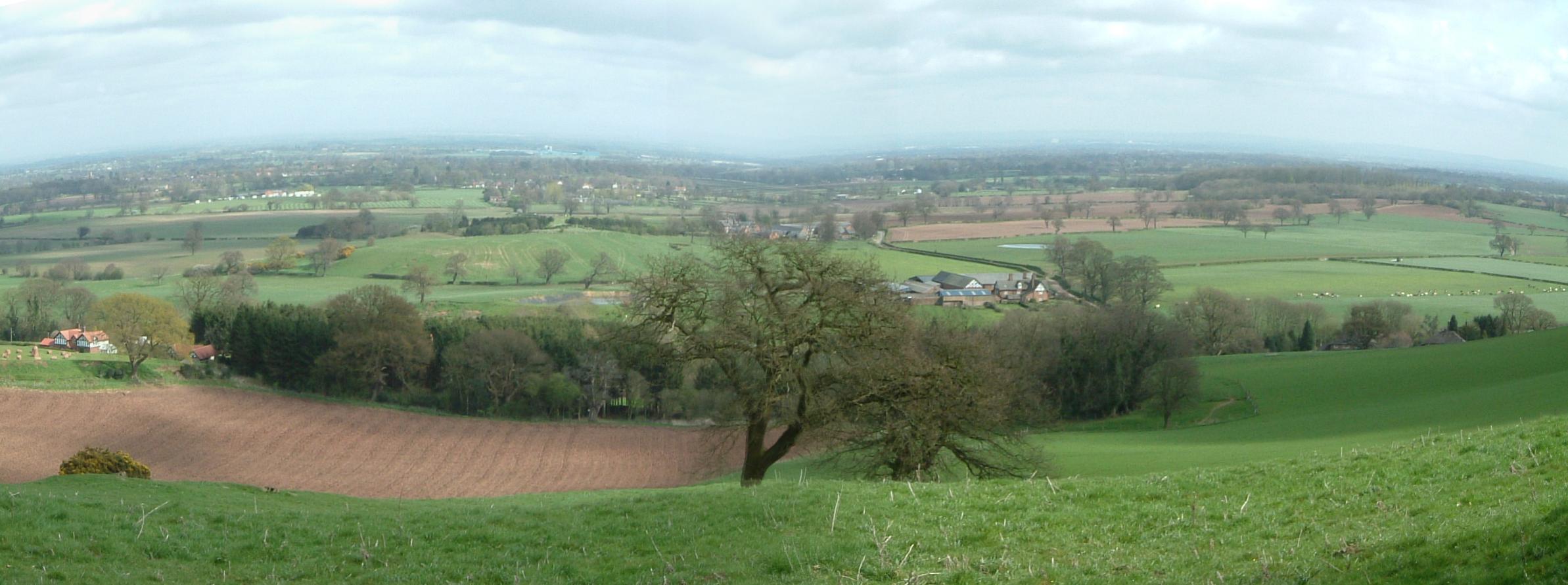 Relatively flat expanse of lowland in North West England, the surface expression of the Cheshire Basin, an area of sedimentary rocks overlain by Mercia Mudstones laid down about 250 million years ago.. Although the settlement was founded during the Iron Age, there is evidence of activity on the site as far back as 8,000 BCE; the hill may have been used as a site of funerary practices during the Bronze Age. Artefacts such as a Bronze Age amber necklace suggest that the site was of high status, and that those occupying it were engaged in long-distance trade. The settlement was occupied into the Roman period, but after its abandonment – probably in the 4th century – it was forgotten until its rediscovery in the 1990s.
The outer ditch is 1.5 m (4 ft 11 in) wide and 1.4 m (4 ft 7 in) deep, and like the inner ditch was cut in the local bedrock.[1] One hundred and twenty-five shards of a rare Iron Age pot were recovered from the outer ditch.[2][3] The material used to make the pot originated about 15 to 20 km (9 to 12 mi) away in Castleton, Derbyshire. It was found in one of the earliest contexts in the ditch, and was probably deliberately placed at the bottom of the ditch as part of a ritual after a significant event such as digging the ditch. The inner ditch had a palisade, but neither the inner nor outer ditch had a bank associated with it.[3]
Location
Mellor lies on the western edge of the Peak District in the Metropolitan Borough of Stockport. The known site of the Iron Age settlement is partially under St Thomas Church and extends into the gardens of several nearby houses. It is on a spur about 220 metres (722 ft) above sea level, between two valleys which drop steeply away and run west where the two small streams in the valleys meet the River Goyt, about 100 metres (328 ft) above sea level. The site commands views of the Cheshire Plain and Alderley Edge to the south and the range of hills to the north.[4] Although there are higher points locally, the site has access to a water supply and the river valleys, and there is flat land to the west that could have been used for agriculture.[5]
Background
Until the 19th century little was known about hill forts; none had been excavated and their original purpose had long been forgotten. In the medieval period their origin was ascribed to various iconic figures such as Julius Caesar, King Arthur, King Alfred, the Danes, and even giants. By the 18th century it was thought that hill forts were Roman in origin.[6] Opinion changed again in the 19th century following a large-scale investigation by Augustus Pitt-Rivers, who concluded that hill forts were built during the Iron Age.[7]
The study of hill forts was popular in the 19th century, with a revival in the 20th century following excavations at Danebury.[8] But it was not until the 1990s that the settlement at Mellor was discovered; the site had a lack of tell-tale earthworks, such as a circular ditch (which would indicate ancient activity).[9] Excavations began in 1998 at a spot where unusual marks had been noted in 1995 during a drought. Instead of the medieval ditch the marks were thought to denote, the ditch of an Iron Age hill fort was revealed.[10] Before excavation began, relatively little was known about the prehistory of the Stockport area before about 1,200 BCE.[11] It was generally thought that the areas of Marple and Mellor had been mostly untouched by prehistoric human activity, including during the Romano-British period.[10] Little is known about Iron Age activity in North West England as pottery is rare on the sites excavated in the region, and there is a dearth of settlement sites. Of the more than 1,300 hill forts found in England[12] relatively few are in the northwest. The paucity of known sites led archaeologist Colin Haselgrove to describe the region as a “black hole” for the Iron Age.[13] Mellor is the only hill fort in Greater Manchester, and one of only four known Iron Age settlement sites in the county.[14]
History
There is evidence of human activity on the site pre-dating the Iron Age, as far back as 8,000–6,000 BCE. During this period Mellor may have been a knap site where flint tools were produced, and also may have been a seasonal camp. More than 200 lithics have been recovered, ranging from the early to the late Mesolithic. A high proportion of the flints are bladed tools, indicating that the people who produced them were hunter gatherers. Bronze Age artefacts are rare on the site, and there is no definitive indication of habitation in this period. Despite this, it is likely that the long-term habitation of the site had its roots in the late Bronze Age.[9]
A flint dagger was discovered on the site. This type of artefact is rare in Greater Manchester; the nearest comparable was in Saddleworth. Its presence has been taken as an indication that during the Bronze Age the site was used for funerary practices. Many of the hills near Mellor are surmounted by Bronze Age funerary monuments, including Brown Low, Shaw Cairn, and Werneth Low, suggesting that Mellor may also have been a funerary site.[15] Also dating from the Bronze Age and found on the site was a rare high-status amber necklace. Amber does not occur naturally in Britain – the nearest source is the Baltic – so it must have been traded over long distances. The necklace was discovered as part of a 4,000‑year‑old burial.[16]

Wikipedia
The hill fort was built in and used throughout the Iron Age, as demonstrated by finds from the site spanning the period.[18] Occupants lived in roundhouses, and habitation of the site continued over a long period. In common with many other hill forts, the site was probably divided into separate areas for habitation, industry, and agricultural activities such as storage, although the layout of these areas changed over time.[19] Excavations indicate that the area enclosed by the inner ditch was used mainly for habitation, while the area between the inner and outer ditches was agricultural. The separation was not necessarily fixed as some of the outer area shows signs that it was used as a living space. The Roman fort of Melandra is nearby.[20]
Fragments of glass, possibly Roman in origin, and shards of pottery dating to the 1st and 2nd centuries AD, suggest that the site was used during the Romano-British period.[18] No Roman structures have been discovered however, and the nature of Roman activity at the site is a source of speculation. The hilltop would have been easily defensible, but local finds suggest that it was a high-status settlement rather than a military outpost, unless a similar feature was located nearby. One possibility for the lack of Roman structures is that the Romano-British inhabitants may have used roundhouses rather than buildings of a typically rectilinear Roman style. This would make them more difficult to differentiate from Iron Age roundhouses and would imply a continuation of local culture rather than an imposition of Roman style. It is also possible that Romans simply influenced the area, rather than actively occupying the site.[21][22]
Investigation
Excavations have been concentrated around the Old Vicarage. By 2004 there were 43 trenches, 14 trial trenches, and 17 test pits. At sites such as Danebury, where there is no modern habitation or built environment, extensive excavations can be undertaken to establish the general layout. But the modern settlement of Mellor extends over the Iron Age hill fort, restricting archaeological investigation. A geophysical survey using magnetometry and ground-penetrating radar nevertheless succeeded in establishing the eastern and northern sections of the ditch encircling the site.[9]
Ivestigation of the site has revealed two ditches, but the chronological relation between them is uncertain.[23] The internal ditch has been cut into the sandstone bedrock and is 4 metres (13 ft) wide and 2.1 m (6 ft 11 in) deep; there was a palisade 3.25 metres (10.66 ft) beyond the inner edge of the ditch. At some point, part of the ditch was refilled and a posthole inserted into it, possibly relating to a gateway. Artefacts recovered from the ditch suggest that the inhabitants of the site had links with salt-producing communities in lowland Cheshire; the Very Coarse Pottery (VCP) which was used to contain the salt at Mellor is similar to fragments recovered from the Iron Age site at Beeston Castle Former royal castle built in the 1220s by Ranulf de Blondeville, 6th Earl of Chester, (1170–1232), some time after his return from the Fifth Crusade.. A layer of charcoal has been radiocarbon dated to 830–190 BCE.[18] The latest deposits in the ditch include hundreds of fragments of Roman pottery dating from the 1st century to the 4th, bronze Roman brooches, and Roman nails.[24]
The outer ditch is 1.5 m (4 ft 11 in) wide and 1.4 m (4 ft 7 in) deep, and like the inner ditch was cut in the local bedrock.[1] One hundred and twenty-five shards of a rare Iron Age pot were recovered from one of the earliest contexts of the outer ditch.[2][3] The material used to make the pot originated about 15 to 20 km (9 to 12 mi) away in Castleton, Derbyshire, and it was probably deliberately placed at the bottom of the ditch as part of a ritual after a significant event such as its completion. The inner ditch had a palisade, but neither the inner nor outer ditch had a bank associated with it.[3]

