
Wikimedia Commons
Standedge is a gritstone escarpment in the moorlandsDominant landscape of Britain's uplands, including many of its national parks. of the South Pennines, between Marsden in West Yorkshire and Diggle in Greater Manchester in northern England. Standedge has been a major Pennine crossing point for more than two thousand years. Routes between Yorkshire and Lancashire towns pass through the Standedge gap.
Iron Age tracks crossed the moorland, and a Roman military road between York to Chester passed over Standedge as did packhorse trails, turnpike roads and today’s A62 road. The old Lancashire-Yorkshire boundary was crossed near the summit. The Huddersfield Narrow Canal and the London and North Western Railway’s three tunnels on its line between Huddersfield and Manchester all pass underground through the Standedge tunnels. The Pennine Way long-distance footpath passes along Standedge in a north–south direction. Much of the area is within the National Trust’s Marsden Moor Estate.
Roads and tracks
Paths and drove roads have crossed the moorland since the Iron Age. The Romans built a military road between their forts at Castleshaw and SlackCastellum (fort) in the Roman province of Britannia, which may have been the Cambodunum mentioned as a station on the road between Deva Victrix (Chester) and Eboracum (York). in the first century AD. After they left, tracks and paths served the local population who travelled on foot or horseback and with packhorses for trade and commerce well into the Middle Ages. Queen Mary passed an Act of Parliament in 1555 making townshipsDivision of an ecclesiastical parish that had civil functions. in the north responsible for the upkeep of the roads and tracks in their area and boundary markers were erected but the tracks and roads remained in a poor state. Travellers, John Ogilby and Celia Fiennes visited the area in the 1600s and remarked on the poor state of the highways as did Daniel Defoe.[1]
Wikimedia Commons
The Manchester and Oldham turnpike road reached the West Riding boundary at Austerlands in 1735 but the Wakefield to Austerlands Turnpike Act was not passed until 1759. John Metcalf, known as Blind Jack of Knaresborough, built the section from Town Gate in Marsden to Standedge Foot in SaddleworthCivil parish in the Metropolitan Borough of Oldham in Greater Manchester, in Yorkshire until government reorganisation in 1974. in 1760 running south of Pule Hill, known as Old Mount Road.[2]
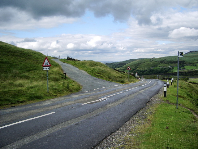
The turnpike was rerouted as Mount Road after Metcalf had returned to build a “floating road” that crossed Standedge through boggy ground. He persuaded the Turnpike Trustees, who wanted the peat dug out down to the bedrock, that he could build the road on layers of heather bundles packed down until they could support layers of gravel and then stone. His method was cheap and quick and still supports the road. Beyond the boggy ground the road followed the route of the Roman Road. Trenches were dug across the road when the Wakefield and Austerlands Toll Road was again diverted in 1839. The diversion is now the route of the A62 which passes north of Pule Hill and through the Standedge Cutting[2] where it reaches a height of 1271 feet (387 m) above sea level.[3]
Canal and rail tunnels

Wikimedia Commons
The Huddersfield Narrow Canal was begun to link towns on either side of the Pennines after it was authorised by Parliament in 1794. Construction of the tunnel, engineered by Benjamin Outram, proved to be a formidable undertaking, and he resigned in 1801; Thomas Telford was appointed in 1806 to finalise the work. The tunnel was opened to traffic between Marsden and DiggleOne of several villages in the Saddleworth parish in the Metropolitan Borough of Oldham, in Greater Manchester between Huddersfield and Ashton-under-Lyne in 1811, when Lively Lady became the first boat to officially pass through.
By 1844 canal freight rates had fallen such that it was uneconomical to continue, and the canal was sold to the London and North Western Railway (LNWR), who used it during the construction of its rail tunnels. The canal was closed in 1944 but re-opened in 2001 through the efforts of enthusiasts.[4]
Wikimedia Commons
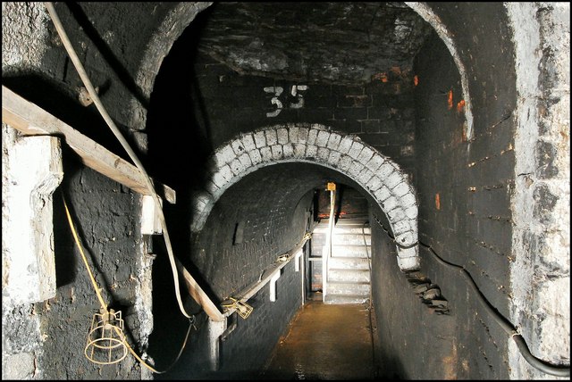
The LNWR opened three tunnels parallel to the canal tunnel. All four are more than three miles long and interconnected by numerous adits and passageways. Thomas Nicholson was the contractor for the first single-track tunnel which was cut from 13 adits driven from the canal tunnel. Spoil was ferried out by a fleet of narrow boats which returned with materials. Construction took a little more than two years and the tunnel opened on 13 July 1849.[4][5]
In 1868 Thomas Nelson tendered for a second single-track tunnel. The canal was again used in its construction and linked to the new rail tunnel by 21 adits that passed under the first tunnel, and again spoil was removed by boats, this time hauled hauled by steam tugs. The second tunnel was finished in 1871. Unable to meet the needs of increased traffic on the Manchester to Hudderfield Line in 1890, the LNWR built the third tunnel with double track that remains in use today. It was engineered by A. A. MacGregor. When it was almost complete, 26 feet (8 m) of the tunnel collapsed in April 1894, blocking it for a week, but it was re-opened on 1 August 1894.[4][5]