
The Rivington Reservoir Chain
Wikimedia Commons
The Rivington Reservoir Chain, or Rivington Pike Scheme, was built for Liverpool Corporation Waterworks between 1850 and 1857 by Thomas Hawksley. He designed the impounding scheme for five reservoirs, a water treatment works on the western edge of the West Pennine Moors and a 17-mile (27 km) long pipeline to storage reservoirs at Prescot near Liverpool. Water from two higher level reservoirs, Rake Brook and Lower Ruddlesworth, was carried south in a channel, The Goit, to three larger reservoirs, Anglezarke, Upper Rivington and Lower Rivington. Treatment works were built at the south end of Lower Rivington and the water was taken to Liverpool via a cast-iron pipe. After 1857 more reservoirs were added to the chain. When built, the chain was the largest such scheme and became a model for schemes elsewhere.
Background

Wikimedia Commons
In the first half of the 19th century Liverpool’s population grew rapidly, leading to a shortage of water.[1] The supply from local wells was inadequate and Liverpool had to look further afield. A site on the edge of the West Pennine Moors below Rivington PikeHill summit on Winter Hill, part of the West Pennine Moors, overlooking the village of Rivington in Lancashire, England. in Lancashire was chosen. In October 1847 Liverpool Corporation voted for the funding required to pass the Rivington Pike Scheme Bill through parliament[2] and obtained the Act of Parliament to construct large reservoirs to collect water from the moorlandDominant landscape of Britain's uplands, including many of its national parks. in the same year.[3] The Rivington catchment is about 10,000 acres and water is supplied by the River Yarrow, the River Douglas and the Roddlesworth and Rake Brooks.[4]
Although land was purchased, opposition to the Rivington Pike Scheme proposed by Thomas Hawksley was strong. The Pikeists, supporters of the scheme won through after a report by Robert Stephenson MP, who had been consulted by the corporation, favoured the scheme over the wells that had traditionally provided the growing town’s water. The works cost £900,000.[3]
Reservoirs
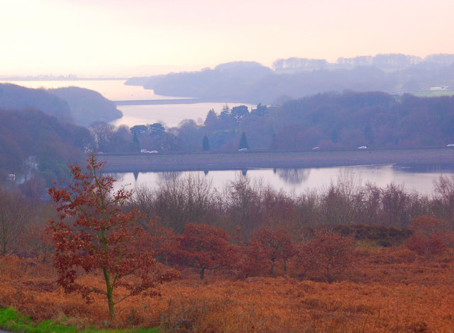
The Rivington Pike Scheme’s three main reservoirs occupy three shallow valleys below the RivingtonVillage in the Borough of Chorley, to the northwest of Bolton, on the fringe of the West Pennine Moors. and AnglezarkeSparsely populated civil parish near Chorley in Lancashire with no village, just scattered farms and the hamlet of White Coppice. Moors between Bolton and Preston. They were built to supply Liverpool with clean drinking water. The reservoirs are bound by embankments. Their combined high-water area is 465 acres (188 ha) and they hold a total volume 2.8 million gallons. All water from the reservoirs was filtered at works at the southern end of the Lower Rivington Reservoir. The Anglezarke, Upper and Lower Rivington Reservoirs appear to be in a single valley, but actually occupy three. Designed by Thomas Hawksley, his first impounding designs, they were constructed between 1850 and 1857 for Liverpool Corporation.[5]
When construction started, a massive influx of workmen moved into the sparsely populated area for the duration of the work. Most were navvies who excavated and built the reservoirs, mostly by manual labour, but also stonemasons and others. They lived in shanty towns of temporary wooden huts near their work.[1] Rivington’s only public house, the Black Lad was demolished to make way for the reservoir and the “Clog Inn” at Anglezarke was unable to cater for all the thirsty workmen, and unlicensed beer sellers made large profits from illicitly brewed ale.[1]
Anglezarke

Wikimedia Commons
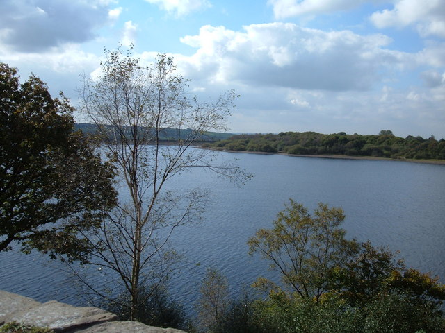
Anglezarke Reservoir has an average depth of 19 feet (6 m). It has three embankments: Heapey at the northern end is 93 yards (85 m) long and 32 feet (10 m) high, Charnock on the western side is 850 yards (777 m) long, 31 feet (9 m) high and Knowsley at the southern end is 240 yards (219 m) long and 46 feet (14 m) high. Its cill level is 43 feet higher than the Upper and Lower Rivington Reservoirs.[5] It covers the greatest area of all the reservoirs at 192 acres (78 ha) and holds 1019 million gallons.[6] Anglezarke is fed by the River Yarrow, which previously ran through the gap filled by the Knowsley Embankment.[6]
Lower Roddlesworth and Rake Brook
The Lower Roddlesworth and Rake Brook Reservoirs to the north, on a tributory of the River Darwen, were built at the same time to supply Anglezarke via the Goit a 3.5-mile (5.6 km) long conduit or canal that is 21 feet (6 m) wide at the bottom.[6][7]
Upper and Lower Rivington
Wikimedia Commons
Water from Anglezarke feeds into the Upper and Lower Rivington Reservoirs which are essentially a single reservoir separated by the 293-yard (268 m) long Horrobin Embankment that carries the road that crossed the valley now occupied by the reservoirs. Combined, they cover 275 acres (111 ha) and contain 1841 million gallons (8369 million L) of water.
The Yarrow Embankment, 363 yards (332 m) long, 40 feet (12 m) high, contains the water on the west side of Upper Rivington Reservoir. Lower Rivington Reservoir is contained by the Millstone, 706 yards (646 m) long, 40 feet (12 m) high, and Horwich Embankments (528 yards (483 m) long, 60 feet (18 m) high). The diverted River Douglas feeds into Lower Rivington via a paved channel in a deep cutting.[7]
High Bullough
The double-ended High Bullough Reservoir [7] predates the Pike scheme. It was built by John Frederick BatemanEnglish civil engineer whose work formed the basis of the modern United Kingdom water supply industry. for Chorley Waterworks to the east of Anglezarke. Liverpool Corporation took responsibility for Chorley’s water supply after taking over High Bullough in 1856.[5]
Yarrow

Wikimedia Commons
The demand for water in Liverpool was still not satisfied and a Bill was passed by parliament in 1867 allowing the construction of another reservoir in the Yarrow Valley to the east of Anglezarke Reservoir, and two more filter beds at Horwich.[8] Yarrow Reservoir, designed by Thomas Duncan, Liverpool’s Borough Engineer, was started in 1867. Fed by the River Yarrow, it is second in capacity to Anglezarke. It covers 73 acres (30 ha) and is up to 90 feet (27 m) deep with a capacity of 1000 million gallons.[9] It is located a short distance to the west and above the Anglezarke and Upper Rivington Reservoirs.[7]
Yarrow is contained by Turners Embankment, 690 yards long and 103 feet high, and the Leicester Vale or Yarrow Embankment, 181 yards long and 90 feet high. It has an impressive 90-foot (27 m) overflow cascade into Anglezarke.[6][7] Water is discharged into Anglezarke via a 250-yard (229 m) tunnel at the west end of the Leicester Vale Embankment not far from the Knowsley Embankment.[7]
Other works
Six filter beds were constructed at the foot of the Horwich Embankment, each 300 feet by 100 feet and 10 feet deep. At their bases were two dry rubble drains above which was a layer of broken stone, layers of gravel and a 30-inch (76 cm) layer of sand. Water drained through the filters into clear water tanks capable of holding 12 million gallons.[10] Water was then conveyed to Liverpool through a 44 inches (112 cm) diameter cast iron pipe.[11] The original sand filters have been replaced by a covered multi-stage treatment plant.[7]
Completion
The Rivington chain became a model for water works all over the world.[8] Water from the reservoirs began to flow in August 1857. At first the water was brown-coloured when it arrived in Liverpool, caused by peat.[8]
Liverpool Corporation was expected to buy the Rivington Hall estate to protect the Rivington watershed when it was offered for sale in 1898. The corporation declined the owner’s offer and the estate was bought by William Lever, Lord Leverhulme who bought it, with manorial rights, for £60,000 in 1900. He offered a large part of the estate as a country park to the people of his home town of Bolton in 1901. Liverpool Corporation changed its mind about the purchase and applied to parliament for a Bill to allow them to acquire the whole Rivington estate to protect their water supply. Lever disagreed and parliament settled the dispute; Lever was allowed to stay in his home, where he developed the gardens, and Lever ParkGrade II listed country park between Rivington in Lancashire and Horwich in Greater Manchester., which he developed and financed, was donated to the people of Bolton. The watershed moorland was sold to Liverpool Corporation and after arbitration, the corporation paid Lever £138,499 and costs of £10,000.[1]
The area attracted walkers and tourists and became known by the sobriquet “little Lake District” in the years after the scheme was completed. [1] The country park is run by United Utilities, the successors of Liverpool Corporation and North West Water, who own the reservoirs.[1]