

Castle Hill and Victoria Tower
Wikimedia Commons
Castle Hill is a scheduled ancient monument in Almondbury overlooking Huddersfield in Kirklees, West Yorkshire. The hilltop shows evidence of the presence of humans for at least 4000 years. The scheduled monument comprises the remains of a late Bronze Age or early Iron Age univallate hillfort[a]A univallate hillfort is one which is bounded by a single line of ramparts.[1] with a single raised bank, a later Iron Age multivallate hillfort, a 12th-century motte and bailey castle and the site of a deserted medieval village.
The Grade II listedStructure of particular architectural and/or historic interest deserving of special protection. Victoria TowerTower on Castle Hill overlooking Huddersfield, constructed as a permanent memorial for Queen Victoria’s Diamond Jubilee. on the summit is the most conspicuous landmark in Huddersfield. The hill has been a place of recreation for hundreds of years and the remains of past occupation have made it a subject of legend, speculation and scientific study.
Geography
Castle Hill rises above the upper Colne Valley about two miles (3.2 km) from Huddersfield in the eastern foothills of the South Pennines. The hill’s oval shape reflects its geology, which comprises bands of sandstones and shales of the Lower Coal Measures laid almost horizontally and topped with resistant Grenoside sandstone. With its steep sides and flattish summit, it is a distinctive and prominent landscape feature, visible from a wide area. The Victoria Tower, on the south-western end of the hill top, is a dramatic feature on the skyline.[2]
History
Archaeological evidence for human activity on Castle Hill is from W. J. Varley who carried out excavations between 1939 and 1973. Late Neolithic flint tools and part of a polished stone axe from about 4000 years ago were discovered that predate the first hillfort by about 1500 years.[3]
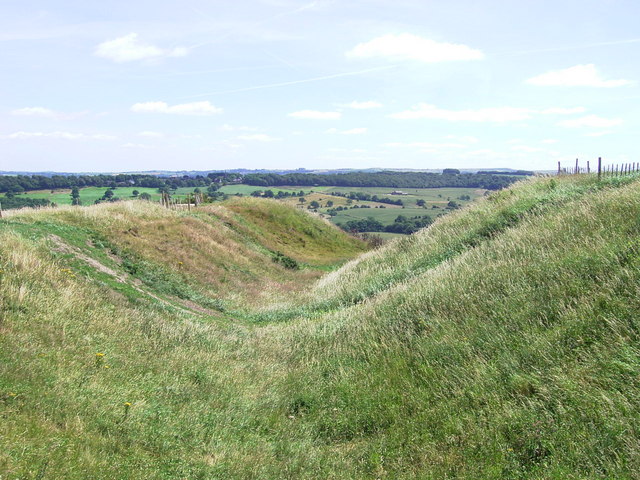
Univallate hillforts are enclosed by a single earthwork, such as a rampart, ditch and a counterscarp bank, near or on the tops of hills above river valleys. They may be defensive features, but also may be sited for access to resources or for communication. Most of the 150 known examples in England were built during the late Bronze Age or early Iron Age, with only a small number in the north.[3]
Wikimedia Commons
The earthworks on Castle Hill were constructed over a period of about 200 years. The first univallate hillfort occupied the 900-foot (274 m) contour on the south-western part of the summit of the steep-sided hill. Dating from the late 7th century BC, it was surrounded by a single 10-foot (3 m) wide bank, possibly with a wooden palisade. The bank had a clay core, and its sides had vertical flagstones supported by a drystone wall. The fort was entered from the north-east, where there was a guardroom.[4]
Early in the 6th century BC a wide ditch was excavated around the first enclosure, and a new bank was raised along the line of the old bank, but in places with a different alignment.[3] Later in that century the hillfort was reconstructed to cover the whole hill top. Ramparts were built round the north-eastern half of the hill and a second bank and a ditch surrounded the new the enclosure. A hundred years later the bivallate hillfort was rebuilt: its inner rampart was widened and raised and a deeper V-shaped ditch was cut outside. Two almost continuous banks were built lower down the hill to surround the complex.[3] The hillfort was abandoned by the end of the 5th century BC, possibly as a result of fire, as vitrification has occurred in the inner rampart.[3] It is not known whether the fire was deliberate or caused by spontaneous combustion of the underlying Coal Measures.[4]
The site remained unoccupied until the earthworks were again modified and reconstructed to create the 12th-century motte and bailey castle,[3][4] which was built on the remains of the ancient hillfort.[4] A broad ditch, 90 feet (27 m) wide and {{convert|30|}} (Undefined conversion) deep, was cut across the hill top, and the excavated earth used to build the motte and surrounding rampart.[3] The castle was built by the de Lacy’s, who were granted licence to crenelate by King Stephen, and its wooden palisade was replaced by a stone wall.[5] The castle well was discovered during excavations along with medieval pottery and metalwork. A small settlement survived until the 15th century, two hundred years after the castle was abandoned.[3]
A beacon was lit on the hill at the time of the Spanish Armada and another was made ready in the event of a Napoleonic invasion. An inn, built on the hilltop in the 19th century, has since been demolished.[3] Large political, religious and other meetings were held on the hill during the 19th century; Chartists held at least four rallies between 1843 and 1848. In 1883 between two and three thousand people braved bitter weather to listen to speeches by union leaders during a weaver’s strike. Other events recorded there included bare-knuckled prize fights, dogfights and cockfights. The Grade II listed Victoria Tower, which commemorates Queen Victoria’s Diamond Jubilee, was opened in 1899.[6] An anti-aircraft battery was built near the south-east end of the hill in the Second World War, and the remains of a range finder can be seen at the north side of the outer bailey.[5]