
Scammonden Reservoir and the M62
Wikimedia Commons
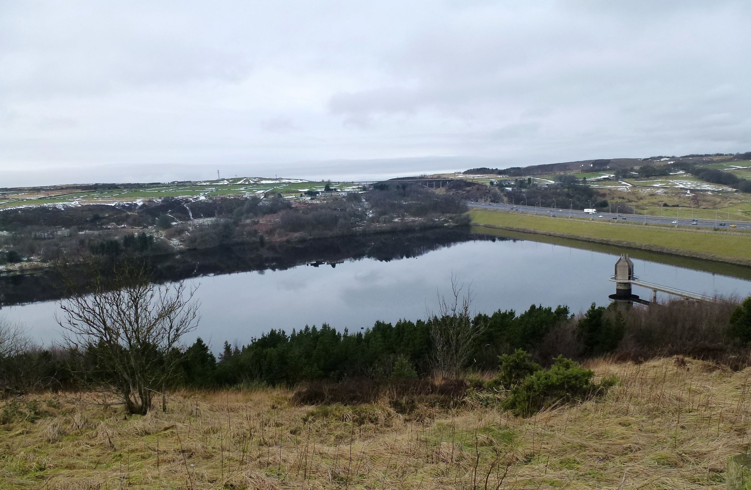
Scammonden Reservoir in the South Pennines supplies water to Huddersfield in West Yorkshire. Its dam is a dual-purpose structure that also carries the M62 trans-Pennine motorway across the Black Brook Valley between junctions 22 and 23. The interdependent motorway and reservoir schemes were officially opened in 1971. The dam is the world’s first to incorporate a motorway, and required an Act of Parliament to sanction its construction.
Buildings in the village of Scammonden Pennine village that was flooded in the 1960s when Scammonden Dam and the M62 trans-Pennine motorway were constructed. were demolished and their remains submerged when the reservoir was filled. A footpath encircling the reservoir is used by walkers, and a sailing club has access to the water.
Location
Scammonden Reservoir was constructed in sparsely populated moorland Dominant landscape of Britain's uplands, including many of its national parks. on the South Pennines east of Huddersfield in West Yorkshire. It is filled by the Deanhead Clough, which first enters the Deanhead Reservoir and leaves it as the Black Brook.[1] The Black Brook continues to the north of the dam, where it is discharged through a tunnel on the eastern side of the valley.[2] Access is from the A640 road, which passes to the south-east; the B6114, which passes over Scammonden Bridge, is to the west.[1]
History
Huddersfield Corporation, requiring more water, proposed building a dam across the Scammonden Valley at the same time as the trans-Pennine motorway was being planned. The dam was planned as a joint project between the Ministry of Transport and Huddersfield Corporation Waterworks. The Huddersfield Corporation Act 1965 sanctioned the construction of the reservoir and dam which was an integral part of the motorway. The dual-purpose structure carries the M62 motorway across the Black Brook Valley in the Pennine hills, the only such structure in Britain, and when it was built, the world. Considerable cost savings were made by building the dam big enough to carry the motorway on its crest.[3] The main contractor for the project was Sir Alfred McAlpine & Sons.[2]

Wikimedia Commons
Many buildings were demolished, and Deanhead village was submerged to make way for the reservoir, but the church on the hillside survived above the waters; its vicarage is now used by the sailing club.[2] The church and adjacent school were at risk of slipping down the hillside into the reservoir and were not used after 1971, when the motorway opened. The church was renovated in 2002 and the old schoolhouse has since been converted into a private dwelling.[4]
Surveying for the motorway began in November 1961, and the route of the carriageway was determined in mid-1963. Excavation in the Deanhead Valley commenced the following year, and for the dam in 1966. About 713,000 cubic metres (25 million ft3) of peat bog were removed to reach the solid rock base, almost 13 metres (43 ft) below ground level.[2]
Reservoir

Wikimedia Commons
The dam’s embankment is 625 m (2,051 ft) long and rises to 63.1 m (207 ft) above the valley floor. At its base it is 435 m (1,427 ft) wide, tapering to 55 m (180 ft) at road level.[2] It has a rolled clay core and graded sandstone fill on both sides.[3] It is built from material excavated from cuttings on other sections of the motorway including clay from between Lofthouse and Gildersome and 3.4 million cubic metres of rock from the Deanhead excavations.[2]
The reservoir is 1.4 km (0.9 mi) long and 73 m (240 ft) at its deepest point, with a surface area, when full, of 42 hectares (104 acres), and holds 7.7 million litres of water. The bellmouth overflow, which is 252 m (827 ft) above sea level, discharges water to the valley below through a tunnel on the reservoir’s eastern side.[2] The valve tower, designed by Rofe, Kennard & Lapworth, is connected to the east bank by a footbridge supported on another tower.[3] Water to supply about 200,000 people in Huddersfield is drawn-off through a 2.5 km (1.6 mi) tunnel.[2] The reservoir started to fill in July 1969, and the area was landscaped and parking and other facilities were provided.
The motorway, which was dependent on the completion of the dam, was opened to traffic on 20 December 1970 and was officially opened by HM Queen Elizabeth II, who unveiled a plaque near the valve tower on 14 October 1971.
Leisure activities
Scammonden Water Sailing Club has the exclusive rights to the water, which means that the activities on the water are either dingy cruising or racing.[5] Other activities occasionally take place usually under the auspices of the scouts. Huddersfield Scout Sailing is a Royal Yachting Association Training Centre run by volunteers for scouts and guides. A scouting activity centre located at the water’s edge also houses the boat workshop for scout sailing.
A wide, surfaced footpath, about three miles (4.8 km) in length, encircles the reservoir, providing access for walkers.

