Wikimedia Commons
Bedford, a suburb of Leigh in Greater Manchester, is one of the three ancient townshipsDivision of an ecclesiastical parish that had civil functions. of Bedford, Pennington and Westleigh, which merged in 1875 to form the town of Leigh; historically, Bedford was in Lancashire.
For much of its history Bedford was largely rural. Its industrial development was stimulated by the construction of the Bridgewater Canal in 1795, after which coal and cotton became the predominant industries until the mid-20th century.
Geography
The township of Bedford was crossed by four brooks from the north, west and east, which united south of Bedford Hall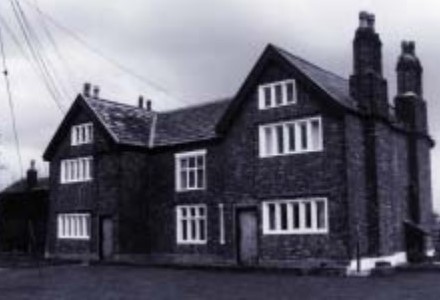 Late-medieval house in Bedford, Leigh near the edge of Chat Moss. to form the Glaze Brook, which was part of the township’s south-western boundary. The Astley and Bedford Mosses
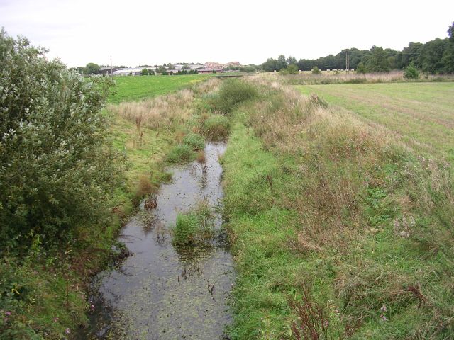 Areas of peat bog south of the Bridgewater Canal and north of the Liverpool and Manchester Railway in Astley and Bedford, Leigh, England. are a surviving part of Chat Moss
 Large area of peat bog that makes up 30 per cent of the City of Salford, in Greater Manchester, England where the elevation of the land is barely 50 feet (15 m) above mean sea-level. The land rises gently to 125 feet (38 m) on the northern boundary.[1]
The township covered 2,826 acres (1,144 ha), partly on the new red sandstone and to the north-east on the middle coal measures of the Manchester Coalfield Part of the Lancashire Coalfield. Some easily accessible seams were worked on a small scale from the Middle Ages, and extensively from the beginning of the Industrial Revolution until the last quarter of the 20th century.. There is alluvium in the ground crossed by the Glaze Brook and its tributaries. The soil is largely clay and the land consisted of meadow and pasture.[1]

Wikimedia Commons
The main road from Manchester to Leigh crosses the township from east to west and a road leading south to Warrington joins it at Butts Bridge.[1] The mile-long Holden Road was constructed at a cost of £53,000 in 1923.[2] The A580 “East Lancashire” Road, which opened in 1934, crosses the township south of the Bridgewater Canal.
In 1952 Leigh Borough Council began building a large council housing estate with facilities for 7,000 people at Higher Folds.[3]
In 1864 the London and North Western Railway opened the Tyldesley LooplineRailway line built in 1864 to connect local collieries to the Liverpool–Manchester main line.Railway line built in 1864 to connect local collieries to the Liverpool–Manchester main line. from Manchester via Eccles and Tyldesley to Kenyon Junction on the Liverpool to Manchester Line via Leigh and Pennington.[4] The station originally named Bedford Leigh served the town. The railway crossed the town on a viaduct which has since been largely demolished.[5] The station and the railway closed in May 1969. The Leigh to Ellenbrook guided busway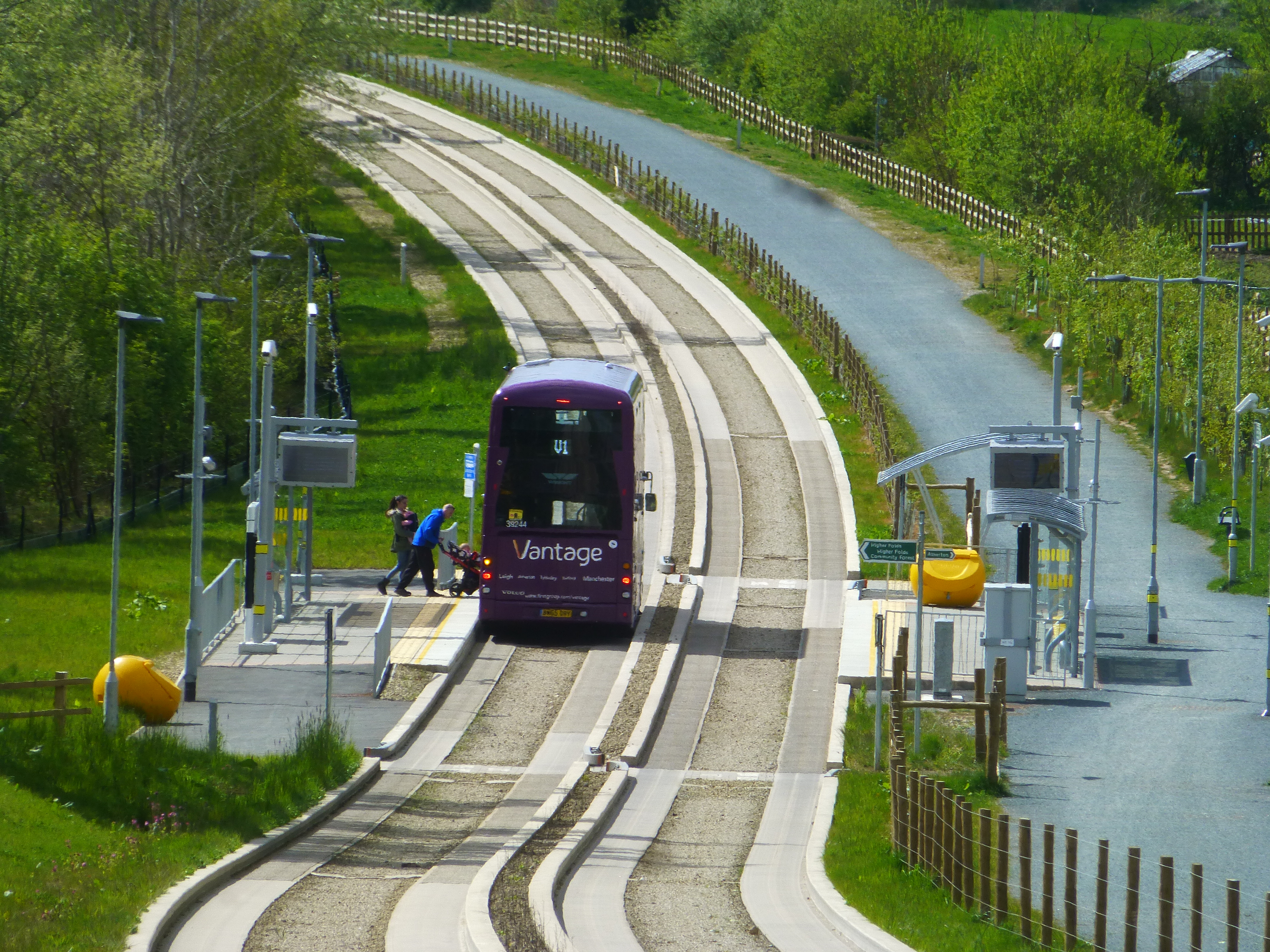 Part of the Leigh-Salford-Manchester bus rapid transit scheme in Greater Manchester, England. It provides transport connections between Leigh, Tyldesley and Ellenbrook and onwards to Manchester city centre on local roads. follows the line of the old railway.
History
Bedford means the “ford of Beda”; it crossed the Pennington Brook, probably near Beaston Bridge on Warrington Road. It was recorded as Beneford in 1200–21 and Bedeford in 1200 and 1296.[1]
The manor, held of the Botelers of Warrington, was divided before the time from which records survive. In 1301 half of the manor was held by the Kighleys, a quarter by the Sales who lived at the moated Hopecarr Hall and the rest by John Waverton of Brick House, which also had a moat. Thomas Shuttleworth lived at Sandypool. which was taken from the Kighley share. Bedford Hall was never a manor house, but was occupied by tenants of the Kighleys, who were absentee landlords.[6] The 1379 Poll Tax, payable by all adults except paupers, lists 33 in Bedford.[7]
The area was rural and a small settlement grew at Butts where the road to Warrington branched from the Leigh to Manchester road. Several inns were built near the junction and in 1641 there was a shop selling amongst other things, “cheese, gunpowder, hops, tobacco”. A corn mill was built by the Breaston Brook.[8]
Sutton or terras lime was obtained in Bedford and Astley where lime kilns operated in the late 18th century. The lime was used in lining the Bridgewater Canal which was completed to Leigh Bridge in 1795.[9]
Industry
Agriculture, fustian weaving and mining from small coal pits near the Astley and Tyldesley border were the chief occupations until the Bridgewater Canal promoted the development of industry and rapid increases in the population during the 19th century.[6] Bedford Brewery was founded in 1823.[10] Corn mills powered by steam were built at the canal basin by Butts Bridge to process wheat imported from the prairies of America through the Port of Liverpool from 1831.[11] Bickham and Pownall built a silk mill Leigh’s silk industry grew after 1827 in and around the area of the old parish when silk was woven on domestic hand looms and later in weaving sheds using silk yarn supplied from Macclesfield by agents from Manchester. in Duke Street in 1833,[12] and Richard le Mare, a French Huguenot immigrant, opened a silk weaving shed in Brewery Lane in 1859.[13] After 1845, the Bedford Foundry made agricultural machinery and fire ranges in premises near the canal.[14]
In 1858 the FletchersOwner of collieries and cotton mills in Atherton in North West England. built a private railway to Bedford Basin to transport coal on the Bridgewater Canal from their collieries at Howe Bridge Suburb of Atherton in Greater Manchester, built as a model mining village in the 1870s by the Fletchers.. After the London and North Western Railway built the Tyldesley LooplineRailway line built in 1864 to connect local collieries to the Liverpool–Manchester main line.Railway line built in 1864 to connect local collieries to the Liverpool–Manchester main line. in the north of the township, John Speakman sank Bedford Colliery
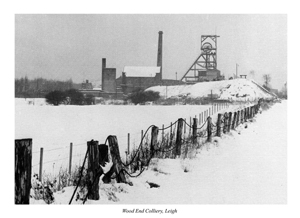 Colliery in Leigh sunk by John Speakman at Wood End Farm in the northeast part of Bedford in 1875. where there was a disaster
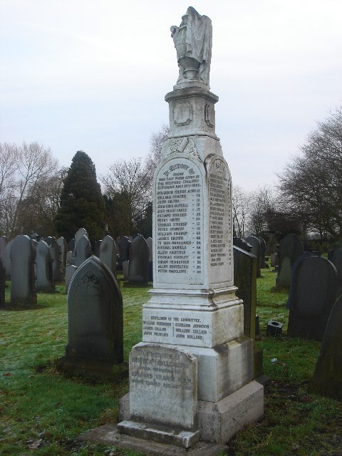 Explosion of firedamp on Friday 13 August 1886 which caused the deaths of 38 miners at Bedford No. 2 Pit in Leigh, on the Lancashire Coalfield. in 1886.

Wikimedia Commons
After power weaving was introduced from the 1850s, some manufacturers employed weavers in their homes and in weaving sheds. Bickham and Pownall owners of Stanley Mill employed 1,000 workers of which 500–600 worked in the mill and the rest in their homes. There were nine silk-weaving sheds in 1870, but most were converted as cotton took over.[15] In 1891 Samuel Brown at Brook Mill, George Griffin on Brewery Lane and Charles Hilton and Son in Charles Street, all in Bedford were manufacturing silk fabrics.
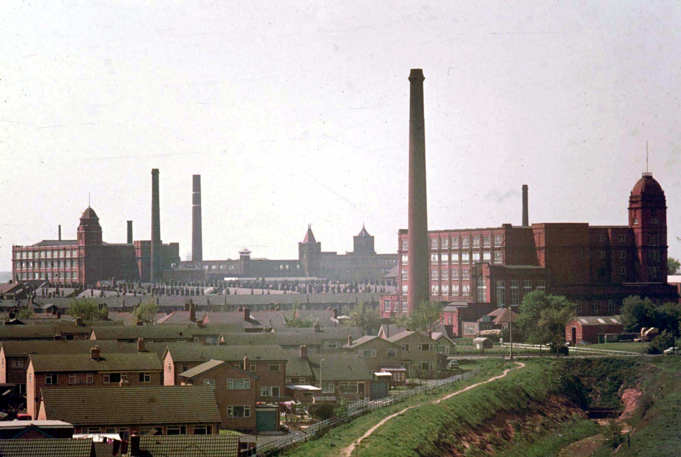
Two clusters of cotton mills were built in Bedford, Jones Brothers started New Mills in 1834: they developed into an integrated mill for spinning and weaving by the Bedford Brook. Large mills, Mather Lane Former complex of cotton mills built on the banks of the Bridgewater Canal in Bedford, Leigh in Lancashire, England., Leigh Spinners
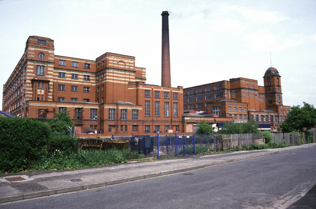 Leigh Spinners or Leigh Mill is a Grade II* listed double cotton spinning mill near the Bridgewater Canal in Bedford, Leigh, England. and several others were built near the Bridgewater Canal.[16] The design of the surviving late 19th and early 20th-century factories along the Bridgewater Canal is an example of the peak of the Lancashire mill-building tradition.
Governance
Historically, Bedford was in the West Derby hundredAdministrative subdivision of a shire., a judicial division of southwest Lancashire where the township was one of six villsHistorical term describing a unit or area of land containing several dwellings that made up the ancient ecclesiastical parishAncient or ancient ecclesiastical parishes encompassed groups of villages and hamlets and their adjacent lands, over which a clergyman had jurisdiction. of Leigh. The townships existed before the parish.[1]
Under the terms of the Poor Law Amendment Act 1834 Bedford became part of the Leigh Poor Law UnionEstablished in 1837, covering townships in the ancient parish of Leigh, plus Culcheth, Lowton and part of Winwick., established on 26 January 1837 and responsible for an area covering the whole of the ancient parish and part of Winwick. The workhouses in Pennington, Culcheth, Tyldesley and Lowton were replaced by Leigh Union workhouse at Atherleigh in the 1850s.[17]
In 1875, Leigh Local Board of Health was established, covering Bedford, Pennington and Westleigh. In 1894 the area of the Local Board, together with part of the Atherton township, became Leigh Urban District, which was granted honorific borough status in 1899 becoming the Municipal Borough of LeighLocal government district in Lancashire, England, created in 1899 and abolished in 1974.. In 1974 the borough was abolished by the Local Government Act 1972 and its area transferred to Greater Manchester to be combined with others to form the Metropolitan Borough of Wigan.
Religion

Wikimedia Commons
Recusants in Leigh adhered to the Catholic Church after the Reformation. They heard Mass in secret at Hopecarr, the home of the Sales, or at Hall House where the Jesuit fathers of Culcheth and Southworth served from the late-17th century. In 1778, before the relaxation of the penal laws against recusants, a chapel was built and public worship resumed. The chapel, from which Chapel Street was named, was replaced on the same site by St Joseph’s Church Active Roman Catholic church in Bedford, Leigh in Greater Manchester, a designated Grade II listed building., designed by Joseph Hansom in 1855.[18]
Now closed, St Thomas’s Church was built in 1840, but was replaced in the early-20th century by a new church on the old site. The church is built of Accrington brick with Runcorn red sandstone facings, it was designed by J. S. Crowther. A mission church dedicated to All Saints was built on Manchester Road and consecrated on 29 October 1938 by the Bishop of Manchester.[19]

