76 suggestions for "coal-mining"
1881 Lancashire miners’ strikeBitter and violent Lancashire miners' strike of 1881 that lasted for seven weeks, and ended with no resolution.
Aberford RailwayPrivate railway connecting Garforth to Aberford in West Yorkshire, closed in 1924.
Andrew Knowles & SonsAndrew Knowles & Sons was a coal mining company that operated on the Manchester Coalfield in and around Clifton, in the historic county of Lancashire, England.
Astley and Tyldesley CollieriesColliery company formed in 1900, became part of Manchester Collieries in 1929, and some of its collieries were nationalised in 1947.
Bank Hall CollieryCoal mine near the Leeds and Liverpool Canal in Burnley, Lancashire., the town's largest and deepest pit.
Bedford CollieryColliery in Leigh sunk by John Speakman at Wood End Farm in the northeast part of Bedford in 1875.
Bedford Colliery explosionExplosion of firedamp on Friday 13 August 1886 which caused the deaths of 38 miners at Bedford No. 2 Pit in Leigh, on the Lancashire Coalfield.
Boothstown Mines Rescue Station Mines rescue station serving the collieries of the Lancashire and Cheshire Coal Owners on the Lancashire Coalfield, opened in 1933.
Bradford CollieryBradford Colliery was a coal mine in Bradford, Manchester, England.
Bradford Colliery BrickworksBradford Colliery Brickworks operated on the site of the Bradford Colliery in Bradford, Greater Manchester, then in the historic county of Lancashire, England,
Bridgewater CollieriesCoal mining company on the Lancashire Coalfield with headquarters in Walkden near Manchester.
Burning wellsPhenomenon known in the area around Wigan in Lancashire from at least the 17th century.
Burnley CoalfieldMost northerly portion of the Lancashire Coalfield, surrounding Burnley, Nelson, Blackburn and Accrington.
CannelType of bituminous coal.
Caphouse CollieryEx-colliery in Overton, near Wakefield, West Yorkshire, now the National Coal Mining Museum for England.
Chaddock PitPit sunk in about 1820 by the Bridgewater Trustees that was connected to the Bridgewater Canal at Boothstown Basin by an underground canal.
Chanters CollieryFormer colliery in Hindsford, Atherton where coal was mined from 1854 until 1966.
Cleworth Hall Colliery
Cleworth Hall Colliery on the Lancashire Coalfield operated between 1880 and 1963 in Tyldesley, Lancashire, England.
Clifton & Kersley Coal CompanyCoal mining company that operated on the south side of the Irwell Valley on the Lancashire Coalfields.
Coal mining terms
This is a partial glossary of common coal mining terms used in the United Kingdom. Some words were in use throughout the coalfields, some are historic and others are local to the different British coalfields.
Combermere CollieryColliery sunk by the Tyldesley Coal Company on the Manchester Coalfield after 1867 in Shakerley, Tyldesley in Lancashire, England.
Combs CollieryDeep coal pit in West Yorkshire, scene of a major explosion in 1839 that killed 139 men and boys working underground.
DampsDamps is a collective name given to all gases other than air found in coal mines in Great Britain. The chief pollutants are carbon dioxide and methane, known as blackdamp and firedamp respectively.
Edward OrmerodEnglish mining engineer and inventor who worked at Gibfield Colliery in Atherton, Lancashire where he devised and tested his safety device, the Ormerod safety link or detaching hook.
Ellenbrook tramwayTramway built by the Bridgewater Trustees in the 1830s to transport coal to the Bridgewater Canal.
Ellesmere CollieryEllesmere Colliery in Walkden, on the Lancashire Coalfield, was sunk in 1865 by the Bridgewater Trustees. Production ended in 1923.
Elsecar CollieriesCollieries in South Yorkshire owned by the Wentworth Fitzwilliams from the late 18th century.
Elsecar engineSteam-driven Newcomen-type atmospheric pumping engine still in its original engine house at Elsecar near Barnsley. Designed by John Bargh of Chesterfield, the engine, is based on one invented by Thomas Newcomen in 1712.
Emley Moor CollieryEmley Moor Colliery refers to several sinkings and drift mines over a large area of Emley, towards the television mast, between Flockton to the north and particularly towards Skelmanthorpe to the south
Fairbottom BobsFairbottom Bobs, an 18th-century Newcomen-type beam engine, was used to pump water from a coal pit near Ashton-under-Lyne, is probably the world’s second-oldest surviving steam engine.
Fletcher, Burrows & CompanyOwner of collieries and cotton mills in Atherton in North West England.
Forest of Dean CoalfieldThe Forest of Dean in west Gloucestershire contains one of the smaller coalfields in the British Isles which for hundreds of years was regulated by a system of freemining.
Gin Pit CollieryColliery that operated on the Lancashire Coalfield from the 1840s in Tyldesley Lancashire, England.
Grange Ash CollieryColliery that operated between 1871 and 1966, south of the A642 road east of Grange Moor crossroads.
Great Boys CollieryGreat Boys Colliery in Tyldesley was a coal mine operating on the Manchester Coalfield in the second half of the 19th century in Lancashire, England.
Great Haigh SoughTunnel or adit driven under Sir Roger Bradshaigh’s Haigh Hall estate between 1653 and 1670, to drain his coal and cannel pits.
Green’s tramroadMineral railway that connected Yew Tree Colliery in Tyldesley to the Bridgewater Canal at Astley.
Hartley Bank CollieryFormer colliery in Netherton, West Yorkshire, opened in 1841 and closed in 1968.
Haydock CollieriesHaydock Collieries comprised several pits, some started in the 18th century, on land owned by the Leghs of Lyme around Haydock on the Lancashire Coalfield in north-west England.
Horse GinHorse-driven engine used in lead and shallow coal mines.
Howe Bridge Mines Rescue StationFirst mines rescue station on the Lancashire Coalfield, opened in 1908 in Lovers Lane Howe Bridge, Atherton, Lancashire.
Howroyd CollieryName for a number of day holes and drifts that worked the coal at the outcrop.
Hugh TremenheereCareer civil servant and inspector of schools, and from 1843 to 1859 the first inspector of mines.
Hulton CollieriesThe Hulton Colliery Company operated on the Lancashire Coalfield from the mid-19th century in Over Hulton and Westhoughton, Lancashire.
Huskar Pit disasterDeaths of 26 boys and girls working underground, drowned by an overflowing stream.
Ingham CollieryFormer colliery to the north of the village of Thornhill in West Yorkshire.
Kaye’s Mineral LineStandard gauge mineral line built to serve the pits owned by the Lister Kayes of Denby Grange in West Yorkshire.
Lancashire and Cheshire CoalfieldThe Lancashire and Cheshire Coalfield in North West England was one of the most important British coalfields. Its coal seams were formed from the vegetation of tropical swampy forests in the Carboniferous period more than 300 million years ago.
Lancashire and Cheshire Miners’ Federation Trade union founded in the aftermath of a bitter and violent seven-week strike in 1881.
Lancashire and Cheshire Miners Permanent Relief SocietyForm of friendly society started in 1872 to provide financial assistance to miners who were unable to work after being injured in industrial accidents in collieries on the Lancashire Coalfield.
Ledston Luck CollieryColliery nine miles east of Leeds and three miles north of Castleford on the Roman Ridge Road, sunk after coal had been proved under the Ledston Hall Estate in 1909.
Manchester CoalfieldPart of the Lancashire Coalfield. Some easily accessible seams were worked on a small scale from the Middle Ages, and extensively from the beginning of the Industrial Revolution until the last quarter of the 20th century.
Manchester CollieriesCoal mining company with headquarters in Walkden, Lancashire, formed in 1929 by the merger of a group of independent companies operating on the Manchester Coalfield.
Mine boatBoats built to transport coal from the Duke of Bridgewater's pits in Worsley.
Mines and Collieries Act 1842Act of the Parliament of the United Kingdom prohibiting all females and boys under ten years of age from working underground in coal mines.
Mines rescueSpecialised job of rescuing miners and others who have become trapped or injured in underground mines because of accidents, roof falls or floods and disasters such as explosions caused by firedamp.
Mining disasters in LancashireMining disasters in Lancashire in which five or more people were killed occurred most frequently in the 1850s, 1860s and 1870s.
National Coal Board Statutory corporation created to run the coal mining industry in the United Kingdom under the Coal Industry Nationalisation Act 1946.
New Lester Colliery Colliery on the Manchester Coalfield opened after 1872 by James and William Roscoe in Tyldesley, Lancashire, England.
Nook CollieryCoal mine on the Manchester Coalfield after 1866 in Tyldesley, Lancashire, England.
Nostell CollieryFormer colliery on the South Yorkshire Coalfield, about four and a half miles south east of Wakefield, on the Nostell Priory estate.
Peelwood CollieryPeelwood Colliery on the Manchester Coalfield in Shakerley, Tyldesley, Lancashire, began producing coal in 1883.
Pendleton CollieryFormer colliery that operated on the Manchester Coalfield from the late 1820s. It was a major employer but was subject to water ingress, which ultimately bankrupted its owner.
Pendleton faultGeological fault stretching for about 20 miles (32 km) from Bolton in Greater Manchester in the north along the Irwell Valley through Pendleton and south to Poynton in Cheshire.
Pit Brow WomenFemale surface labourers at British collieries. They worked at the coal screens on the pit brow (pit bank) at the shaft top until the 1960s. Their job was to pick stones and sort the coal after it was hauled to the surface.
Ramsden’s Shakerley CollieriesRamsden’s Shakerley Collieries was a coal mining company operating from the mid-19th century in Shakerley, Tyldesley in Lancashire, England.
Robert DaglishRobert Daglish (1779–1865) was a colliery manager, mining, mechanical and civil engineer at the start of the railway era.
Robert IsherwoodRobert Isherwood (1845–1905) was a miner’s agent, local councillor and the first treasurer of the Lancashire and Cheshire Miners’ Federation.
St George’s Colliery
St George's Colliery, known locally as Back o't' Church, was a coal mine on the Manchester Coalfield that was sunk in 1866 in Tyldesley, Lancashire, England.
Thornhill CollieryFormer colliery in the West Riding of Yorkshire, worked from the 16th century until 1972.
Tyldesley Coal CompanyCoal company was formed in 1870 in Tyldesley on the Manchester Coalfield, in the historic county of Lancashire, England.
Walking Horse (locomotive)Lancashire’s first steam locomotive, built by Robert Daglish in 1812 at the Haigh Foundry for colliery owner, John Clarke; it entered service the following year.
Wharton Hall CollieryWharton Hall Colliery was in Little Hulton on the Lancashire Coalfield in Lancashire, north west England.
Worsley dry docksEarliest surviving example of a dry dock on Britain's canals.
Worsley Navigable LevelsExtensive network of underground canals that drained the Duke of Bridgewater's coal pits emerge into the open at the Delph in Worsley, Greater Manchester.
Yew Tree CollieryFormer coal mine operating on the Manchester Coalfield after 1845 in Tyldesley, which was then in the historic county of Lancashire, England.
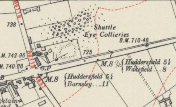

 Tract of moorland more than 700 feet above sea level gave its name to this Yorkshire village. in West Yorkshire, between Wakefield and Huddersfield on the A642 road.
