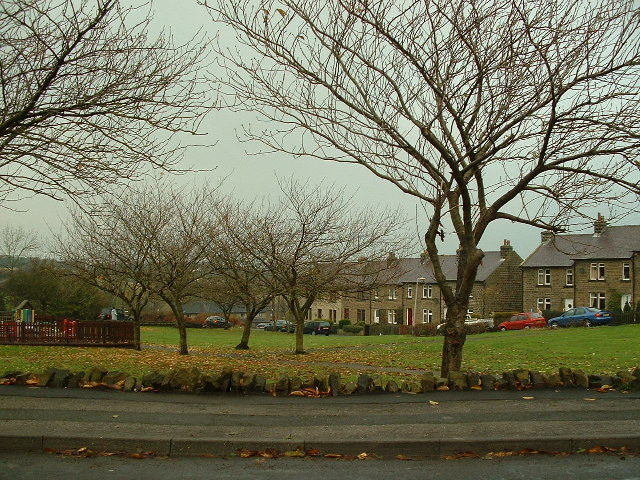
Grange Moor, a tract of moorlandDominant landscape of Britain's uplands, including many of its national parks. more than 700 feet (213 m) above sea level, gave its name to the village that developed during the Industrial Revolution. Since 1974 the village has been in the Kirklees district of West Yorkshire, England, six miles (10 km) from Huddersfield and nine miles (14 km) from Wakefield. The moorland was granted to the monks of Byland Abbey in medieval times and used for sheep grazing. The village, a product of the Industrial Revolution, started to grow when the underlying coal was mined from shallow pits and a deep pit, Shuttle Eye CollieryColliery on the South Yorkshire Coalfield at Grange Moor in West Yorkshire, between Wakefield and Huddersfield on the A642 road., was sunk in the 1850s.
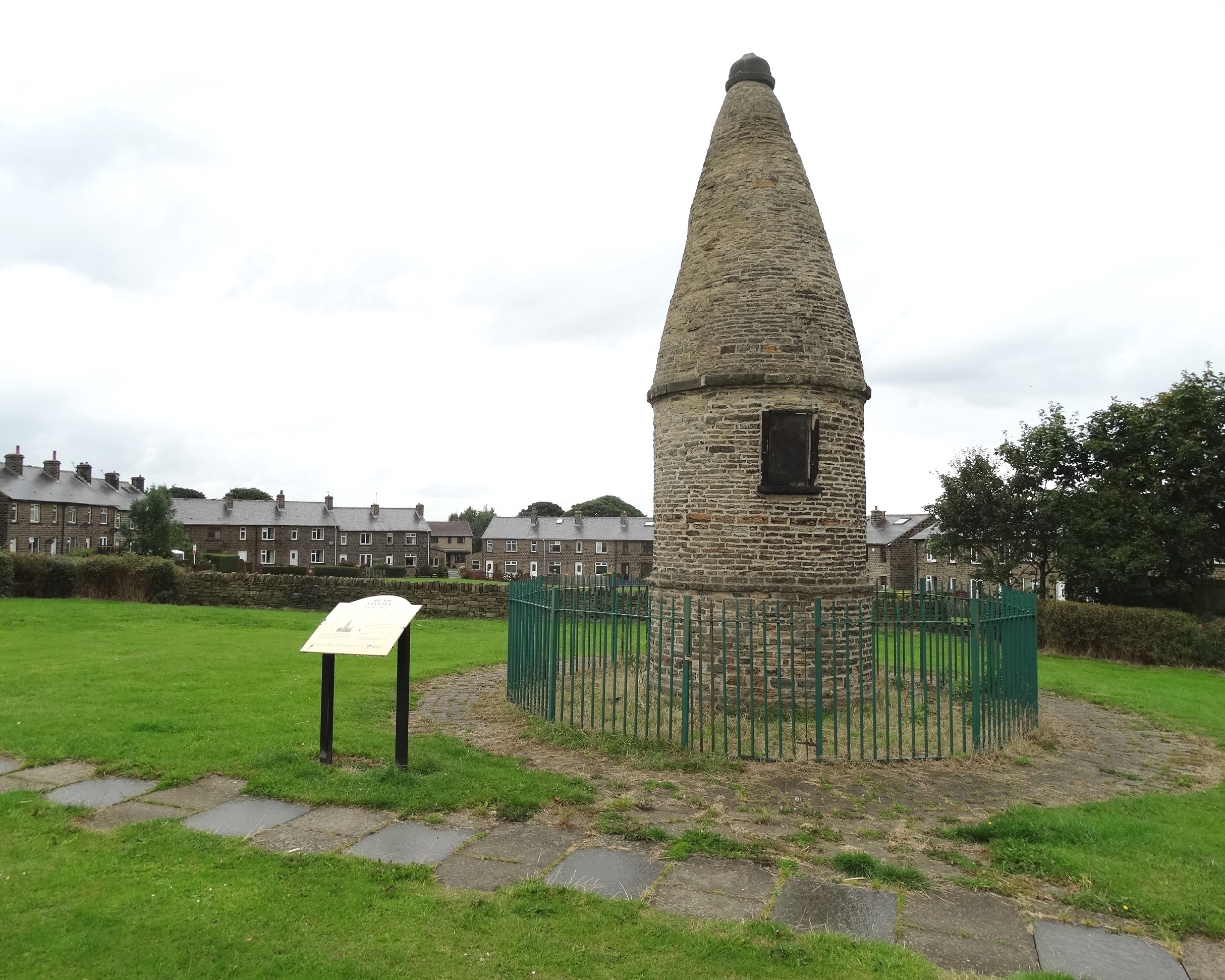
An unusual landmark is the Dumb steeple, the village’s oldest structure. The east window of St Bartholomew’s Church, which was built in 1898, was damaged by bombs during the Second World War.
Geography
Grange Moor, on the road from Huddersfield to Wakefield, is situated on hilly land to the north of crossroads where the A642, A637 and B6118 roads meet. The village is six miles (10 km) from Huddersfield and nine miles (14 km) from Wakefield. The B6118 connects it to Kirkheaton, the A637 to FlocktonRural village stretched out along the Barnsley to Huddersfield road in Kirklees, West Yorkshire, taking its name from a Viking settler. and Barnsley. The village is more than 700 feet (213 m) above sea level.[1] Coal mining and quarrying were once significant industries in Grange Moor.
History
The monks of Byland Abbey in North Yorkshire were granted land at Denby Grange in around 1200. In medieval times grangesMonastic granges were outlying landholdings held by monasteries independent of the manorial system. They could be of six known types: agrarian, bercaries (sheep farms), vaccaries (cattle farms), horse studs, fisheries or industrial complexes. were part of the outlying landholdings held by the monastery for sheep grazing. Grange Moor was named at this time. The monks had left by the 14th century and after the dissolution of the monasteries the land was sold and sheep farming continued until the late 18th century.[2]
Dumb steeple Wikimedia Commons
The village’s oldest standing structure is a curious folly Ornamental structure with no practical purpose, built to enhance a designed garden or landscape., the Dumb steeple, which according to the plaque was re-built in 1776 by landowner, Richard H Beaumont Esquire of Whitley Beaumont.[3]
A failed attempt at uprising took place on Grange Moor in 1820, a time of mistrust in the political system, unrest and unemployment after the Napoleonic Wars and PeterlooCavalry charge on 16 August 1819 into a crowd of 60,000–80,000 gathered at St Peter's Field, Manchester, England to demand the reform of parliamentary representation . On 1 April about 2000 men in Huddersfield marched intending to take the town from the garrison, but dispersed when expected reinforcements did not arrive. On 12 April about 400 men with flags and arms from Barnsley, Dodworth and Monk Bretton, believing they were part of a postponed uprising, marched to Grange Moor expecting to be joined by others but found only 20 men from Huddersfield. Believing they had been betrayed the men fled and troops sent to confront them arrested 17 men.[4]
In 1820 Grange Moor was still open land.[4] The village was established after coal was discovered, and shallow mining began in the 19th century.[2] Clough Gate, Brown Hill and Square Pit were among the small coal pits and day holes that accessed the shallow seams.[5] The largest pit, Shuttle Eye CollieryColliery on the South Yorkshire Coalfield at Grange Moor in West Yorkshire, between Wakefield and Huddersfield on the A642 road., was started in 1837, and its deep shafts were sunk in the 1850s by Benjamin Lockwood, the licensee of the Blacksmiths Arms public house at the crossoads.[6]
Grange Moor Brass Band was formed in 1854, possibly in connection with Shuttle Eye Colliery. The village school was established in 1879.[2]
St Bartholomew’s Church was built as a mission to Kirkheaton Parish Church in 1898, after services had been held in the village;[7] the first took place in the dressmaker’s cottage in 1894. Whitley Upper Urban District Council approved plans for the church building in 1897.[2] Several pieces from the church’s east window were blown out when a German bomber dropped its bombs during the Second World War.[7] Methodists had worshipped in Chapel Row from 1848 until 1878 when the Methodist Chapel on Briestfield Lane was built. It closed in 1996.[2]
Governance
Grange Moor was in the townshipDivision of an ecclesiastical parish that had civil functions. of Whitley UpperTownship in the ancient parish of Kirkheaton, in the West Riding of Yorkshire. in the ancient parishAncient or ancient ecclesiastical parishes encompassed groups of villages and hamlets and their adjacent lands, over which a clergyman had jurisdiction. of Kirkheaton in the West Riding of Yorkshire. The township covered 1955 acres (791 ha) of fertile land and the hamletsRural settlement smaller than a village. of Whitley Upper and Denby GrangeEstate and mansion in Whitley Upper, between Huddersfield and Wakefield, in the West Riding of Yorkshire, seat of the lister Kaye baronets.Estate and mansion in Whitley Upper, between Huddersfield and Wakefield, in the West Riding of Yorkshire, seat of the lister Kaye baronets.. The Beaumonts of Whitley Hall, descendants of a Knight Hospitaller of St John of Jerusalem, were granted the manor in the reign of Henry III. Also in the township was Denby GrangeEstate and mansion in Whitley Upper, between Huddersfield and Wakefield, in the West Riding of Yorkshire, seat of the lister Kaye baronets.Estate and mansion in Whitley Upper, between Huddersfield and Wakefield, in the West Riding of Yorkshire, seat of the lister Kaye baronets., seat of the Lister Kayes.[8]
Whitley Upper Urban DistrictAdministrative areas that had district councils and shared local government responsibilities with a county council. was established in 1894 and abolished on 1 April 1938 to become part of Kirkburton Urban District.[9][10]
We use cookies to optimise our website and our service. By clicking on “All cookies”, you consent to us using all cookies and plug-ins as described in our Cookie policy.
Functional cookies
Always active
The technical storage or access is strictly necessary for the legitimate purpose of enabling the use of a specific service explicitly requested by the subscriber or user, or for the sole purpose of carrying out the transmission of a communication over an electronic communications network.
Preferences
The technical storage or access is necessary for the legitimate purpose of storing preferences that are not requested by the subscriber or user.
Statistics
The technical storage or access that is used exclusively for statistical purposes.The technical storage or access that is used exclusively for anonymous statistical purposes. Without a subpoena, voluntary compliance on the part of your Internet Service Provider, or additional records from a third party, information stored or retrieved for this purpose alone cannot usually be used to identify you.
Marketing
The technical storage or access is required to create user profiles to send advertising, or to track the user on a website or across several websites for similar marketing purposes.