

Emley Parish Church
Wikimedia Commons
Emley, a rural villageSmall rural collection of buildings with a church. in the South Pennine fringe, midway between Huddersfield and Wakefield in West Yorkshire, originated in Anglo-Saxon times. Farming was the main industry but by the 19th century rich coal deposits had made coal mining an important industry along with weaving. Coal was mined from small pits in medieval times as was ironstone at Bentley GrangeShaft mounds and earthworks south of Bentley Grange Farm are the remains of a medieval iron mining site between Emley and West Bretton in West Yorkshire. . Emley Moor CollieryEmley Moor Colliery refers to several sinkings and drift mines over a large area of Emley, towards the television mast, between Flockton to the north and particularly towards Skelmanthorpe to the south was a major employer until 1985.
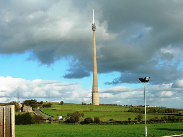
The landmark Emley Moor transmitting station was built a mile to the west of the village.
Geography
Wikimedia Commons
Emley’s ancient parish covered 3,120 acres of mostly farmland on hilly ground between Huddersfield and Wakefield. The village is built on a high undulating plateau that reaches up to 265m AOD.[1] The land slopes into the Upper Dearne Valley to the south.[2] No major roads, railways or canals pass through the village[3] which is 6.4 miles east of Huddersfield and 7.1 miles west of Wakefield. Grange MoorA tract of moorland more than 700 feet above sea level gave its name to this Yorkshire village. is to the north-west, FlocktonRural village stretched out along the Barnsley to Huddersfield road in Kirklees, West Yorkshire, taking its name from a Viking settler. to the north, Skelmanthorpe to the south-west, Clayton West to the south-east and West BrettonVillage and civil parish in the Wakefield District of West Yorkshire. is to the east.[4] A mile west of the village, the 330m tall Emley Moor transmitting station is a local landmark visible across the district. It is the UK’s tallest free standing structure.[1]
The underlying geology is Millstone Grit overlain by mudstone, siltstone and sandstone of the Pennine Coal Measures in the exposed area of the South Yorkshire Coalfield.[1] Emley Moor Colliery exploited the coal from several pits and drifts.[2] Tankersley ironstoneNamed from its outcrop at Tankersley near Barnsley in South Yorkshire. occurs as thin seams and nodules of siderite in the mudstone above the Flockton Thick coal seam.[5]
Demographics
Census data: Emley
At the 2011 Census, the Emley built-up area had a population of 1,497, with an average age of 44.8 years. The built-up area occupies 42.25 hectares (104.40 acres), giving a population density of 35.4 persons per hectare.[6]
History
Emley’s name is derived from an Old English personal name, Em(m)a or Eama, and lēah, a wood or woodland clearing.[7][8] The Saxon settlement was at Emley Park south of the village. The village was recorded as Amalaie and Amelai in the Domesday Book and as Emmeley by the 13th century.[9]
After the Norman Conquest, Godric, a descendant of the Saxon settlers, was retained as lord of the manor and Emley became part of the Royal Manor of Wakefield.[10] He passed the manor to his son, Ketelbern, some time after 1080, and he passed it to his son Godric whose descendants adopted the Norman practice of having a surname. William Fitzgodric, born in 1140, was followed by his son William using the surname Fitzwilliam.[11] The Fitzwilliams who retained the manor for many generations lived in a moated, timber-framed house on the site of the Old Hall in Emley Park south of the village.[12][2]} Sir John Fitzwilliam and the rector died in 1348, possibly from the Black Death, and by 1350 the manor was described as “ruinous” and the Fitzwilliams moved to Sprotborough.[13]

Wikimedia Commons
The manor eventually passed by marriage to Sir Henry Savile [14] of Thornhill Hall.[15] The Saviles never lived in Emley; their estate was managed by stewards or agents.[16] John Saville inherited the manor in 1856 and was created 1st Baron Savile in 1888. I in 1931, George Savile inherited the manor and bought Gryce Hall near Kirkburton.[17]
At the village crossroads are the remains of the market cross. Sir Thomas Fitzwilliam obtained the right to hold a weekly Thursday market and five-day May fair from King Henry II in 1253. The market cross, more than three metres high, was destroyed by Roundheads during the English Civil War and is now a stump.[18] John Turton sold his wifeWay of ending an unsatisfactory marriage by mutual agreement that probably began in the late 17th century, when divorce was a practical impossibility for all but the very wealthiest. Mary to William Kaye of Scissett for two half crowns by the cross during Emley Feast in 1826. She returned to her lawful husband after Kaye’s death.[19] In the 1830s the Temperance Movement was active and attempted to attract people away from public houses by providing the Temperance Hotel and Refreshment Room, styled on one created by Edward Parker in Leeds.[20]
Schools
A school was founded in 1673 by John Wiglesworth. A British schoolEstablishments offering education to the children of Nonconformist parents, initially run by a single teacher using the monitorial system. was opened in 1852 and the parish hall was opened as a National schoolSchools set up by Anglican clergy and their local supporters, initially run by single teachers using the monitorial system. for infants in 1872. The schools were amalgamated by the West Riding County Council in 1928.[21]
Industry
Iron ore from the Tankersley seam was mined at Bentley Grange where a forge was built by the monks of Byland Abbey under a licence granted by Sir William Fitzwilliam in 1217 and another was endorsed by his son Sir Thomas Fitzwilliam in 1237.[22] GrangeMonastic granges were outlying landholdings held by monasteries independent of the manorial system. They could be of six known types: agrarian, bercaries (sheep farms), vaccaries (cattle farms), horse studs, fisheries or industrial complexes. , a name associated with many buildings in and around Emley. The remains of bell pits around Bentley Grange, a scheduled monument, are medieval workings from when iron ore was again mined from the Tankersley seam.[23]
The steep scarp slope overlooking the Dearne Valley contains the remains of medieval day holes where coal was dug for iron forging.[24] “Cole mynes” at Emley Woodhouse were operating in 1597 and coal was possibly mined from shallow shafts on Emley Moor in the 17th century. The Jaggar family owned Emley Moor Colliery in 1821 when winding was done by a horse ginHorse-driven engine used in lead and shallow coal mines..[25] Although farming was the main industry in Emley, by the 19th century rich coal deposits had made coal mining an important industry along with weaving. Mining was a source of employment until 1985 when Emley Moor Colliery closed after the year-long miners’ strike. The site is now a business park.[26]
Religion
A pre-Conquest church was replaced by a Norman church before 1150. St Michael the Archangel’s Church is described on the church website as “a fascinating architectural jigsaw puzzle” and a “jumble of stonework belonging to various centuries” with fragments of Norman work incorporated into the walls.[27] It was begun in the 14th century using materials from the old church but much of the interior dates from the late-medieval period and its tower is 15th century[28]
Non-conformity arrived in 1798, when John Silverwood was given a licence to preach and use premises as a place of worship for Protestant dissenters. A Wesleyan chapel was built in 1811, but closed in 1913. Primitive Methodists built a chapel in 1912 to replace their 1850 building.[18]