
St Piran’s Church
Wikimedia Commons
Perranarworthal is a mostly rural civil parishSmallest administrative unit in England. in West Cornwall. It covers about 1250 acres (506 ha) from Bissoe, where an ancient bridge crosses the Carnon RiverHeavily polluted river in West Cornwall, draining the historic mining area of Gwennap., its western boundary; its southern boundary follows the River KennallRiver in south-west Cornwall.. The parish’s population of 1550 is spread between clusters in Churchtown, Perran Wharf, Perranwell and Tarrandean (Perranwell Station).
The river valleys were the site of great industrial activity during the late 18th and 19th centuries. Tin and gold were found in the river, and an arsenic factory provided work for the locals. The Perran FoundryCornish foundry established in 1791 to supply steam-engine pumps and heavy machinery to mines, waterworks and ironworks.Cornish foundry established in 1791 to supply steam-engine pumps and heavy machinery to mines, waterworks and ironworks. manufactured steam engines for local mines and for export.
In recognition of the area’s industrial past, part of the parish is in the World Heritage site that includes the Gwennap Mining District with Devoran, Perran & Kennall Vale.[1]
Geography
Perranarworthal covers less than 3 square miles (7.8 km2) of land that rises from sea level in the south-east to 308 feet (94 m) above sea level at its highest point. Most of the area is gently rolling farmland at the head of the Fal estuary. The Carnon and Kennall Rivers which form the eastern and southern boundaries flow into the estuary. Trewedna Water flows between them, west to east, through Perranwell to the Carnon Valley.[2] Streams flowing through the mineral rich mining area around Gwennap feed into the Carnon River were rich in tin that settled in the deep alluvial deposits laid down in its valley and into the estuary.[3] The Great County AditSystem of underground tunnels that drained tin and copper mines between Redruth and Bissoe in west Cornwall., which dewaters numerous mines in the area and discharges into the river above Bissoe.

Wikimedia Commons
The main areas of settlement are Perranwell, Greenwith, Tarrandean or Perranwell Station, ChurchtownEcclesiastical parishes in Cornwall sometimes have a parish church situated in a churchtown. and Perranwharf with a combined population of 1550.[2]
The A39 Truro to Falmouth road runs south-west along the southern boundary and the A393 Redruth to Falmouth road passes along the west where it is joined by the minor road through Perranwell from Carnon Downs. The line through Perranwell Station is on the Maritime Line between Truro and Falmouth. The parish has a primary school, village hall, post office and village shop and two public houses.[4]
History
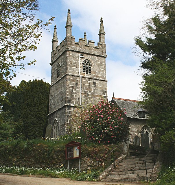
Perranarworthal means St Piran’sActive Anglican church in Perranarworthal, dedicated to Cornwall's patron saint. (church) beside the marsh. St Piran was a Welsh or Irish saint who became the patron saint of tinners. Ar worthal[a]ar is Middle Cornish meaning before, facing or beside and gothel, Middle Cornish meaning watery ground was the name of the manor which faced the marshy ground beside the River Kennall.[5]
Perranarworthal’s Norman chapel was dependent on the church in Stithians in the 12th century.[6] The Norman chapel was rebuilt in the 15th century, and its tower is all that remains after the chancel was rebuilt in 1842 and again in 1882, by the architect James Piers St Aubyn.[7]
Industry
Deep alluvial deposits laid down in the Carnon River between Bissoe and DevoranRural village in West Cornwall. sustained the most important tin stream worksProcess for extracting tin from the mineral cassiterite. in Cornwall in the 18th century.[3] Evidence of the tin industry from the early Bronze Age is scant, but William Jory Henwood (1805–1875) described a discovery made in March 1823. Workers at the stream works uncovered a Bronze Age human skeleton in the tin–bearing sediment about 22 feet (7 m) below high water in the Carnon Valley.[8] Alongside the tin, small amounts of gold were also found in the sediments. A large nugget was found in 1808, now displayed in the Royal Cornwall Museum.[9]
In 1769 George Fox leased the wastelands in the bottom of the Kennall Valley on the Mylor (south) side of the river from Lord Mount Edgcumbe where Perranwharf was established an where his sons established the Perran FoundryCornish foundry established in 1791 to supply steam-engine pumps and heavy machinery to mines, waterworks and ironworks.Cornish foundry established in 1791 to supply steam-engine pumps and heavy machinery to mines, waterworks and ironworks. in 1791.[10] Perran was largely dependent on orders from the Gwennap mines, but copper production declined rapidly after 1860 because the mines were becoming worked out and competition from abroad.[11] Perran closed in March 1879 with the loss of 400 jobs, causing great distress in the parish.[12]
Arsenic, a contaminant that affected copper and tin production in Cornwall, was burned off until mine owners realised that it was of value. Cornwall’s first refinery to recover arsenic from mine waste was set up at Tarrandean in 1817.[13]
Transport

The road through Perranwell Station is the old turnpike road leading over the Carnon Bridge and up Old Carnon Hill through Carnon Downs to Truro, constructed in 1754. It was the first and largest in Cornwall, linking Falmouth with London. A new turnpike road, now the A34, was constructed in 1828, taking the route over a new causeway at Devoran then following the creek past the Perran Foundry. Its construction was overseen by William McAdam, under instruction from his father, John Loudon McAdam, who had moved to Falmouth.[14]
The Cornish Railway opened Perranwell Station on its heavily engineered main line from Plymouth to Falmouth in August 1863. Built as a broad-gauge single-track line, the line from Truro approached Perranwell Station over the original wooden viaduct over the Carnon River and headed towards Falmouth over the short Perran Viaduct before passing through the 374-yard (342 m) Perran Tunnel. When the line to Penzance was constructed, the Truro to Falmouth section became a branch line, now marketed as the Maritime Line.