
The Lancashire and Cheshire Coalfield in North West England was one of the most important British coalfields in the 19th and 20th centuries. Its coal seams were formed from the vegetation of tropical swampy forests in the Carboniferous period, more than 300 million years ago.
The Romans may have been the first to use coal in Lancashire, and its shallow seams and outcrops were exploited on a small scale from the Middle Ages and extensively after the start of the Industrial Revolution. The coalfield was at the forefront of innovation in coal mining, prompting the country’s first canals, use of steam engines and creating conditions favourable for rapid industrialisation.
Pits on the coalfield were at their most productive in 1907, when more than 26 million tons of coal were produced; by 1967 just 21 collieries remained. Parkside Colliery in Newton-le-Willows, the last deep mine to be sunk on the coalfield, was closed in 1993.
Geology
The geology of the coalfield consists of the coal seams of the Upper, Middle and Lower Coal Measures, layers of sandstones, shales and coal of varying thickness, which were laid down in the Carboniferous period more than 300 million years ago.[1] The coal seams were formed from the vegetation of tropical swampy forests.[2] The coal in Lancashire is bituminous, with 30–40% volatile matter varying in hardness from seam to seam.
The Coal Measures are more than 1,200 metres (3,937 ft) thick, of which coal accounts for about 4%.[3] They were subjected to folding, which accounts for the dip towards the south and west. The coalfield is crossed by several major faults that generally run in a north and south direction; the most significant easterly fault throws the strata down to the east. It was worked from Fairbottom in Ashton-under-Lyne across the River Medlock to Oldham and onwards to the west of Rochdale. The Red Rock Fault skirts the north-west extremity of the North Staffordshire coalfield towards Macclesfield and Poynton Colliery in Cheshire. The Irwell Valley or Pendleton FaultGeological fault stretching for about 20 miles (32 km) from Bolton in Greater Manchester in the north along the Irwell Valley through Pendleton and south to Poynton in Cheshire. passes Clifton and Kearsley, where it throws the coal measures down to the north-east.[3] It has a throw of 3000 feet (900 metres) and the area is still geologically active and subject to earth tremors.[4] A fault with a large horizontal but small vertical throw is found at Tyldesley.[3] In the deep mines[a]In Lancashire a coal seam is referred to as a mine and the coal mine as a colliery or pit. at the southern edge of the coalfield, the Plodder mine in Leigh and the Arley mine in Tyldesley were hot: the miners worked in temperatures of more than 100ºF (38ºC).
Five substantial faults affect the Wigan Coalfield. They run almost parallel to and equidistant from each other. The Great Haigh Fault begins near Bickershaw Colliery and passes northward through Hindley, Kirkless Hall, Haigh, and Arley to the west of Adlington Park. The Great Standish or St Catherine’s Fault has a downthrow to the east and passes under St Catherine’s Church at Ince. The Giant’s Hall Fault passes by Abram, west of Ince Hall Colliery, west of Gidlow and under Giant’s Hall Farm to Standish Church. The Great Shevington Fault passes by Hawkley Hall and east of Kirkless Hall. The Great Pemberton Fault is a downthrow, and passes Pemberton, Orrell and to the west of Shevington. Further west are the Great Upholland Fault, the Lathom Fault the Great Boundary Fault stretching from Bickerstaffe to about two miles (3 km) east of Ormskirk.[3]
Geography
The coalfield on the western side of the Pennines is separated by the Rossendale anticline. To the north-east is the Burnley Coalfield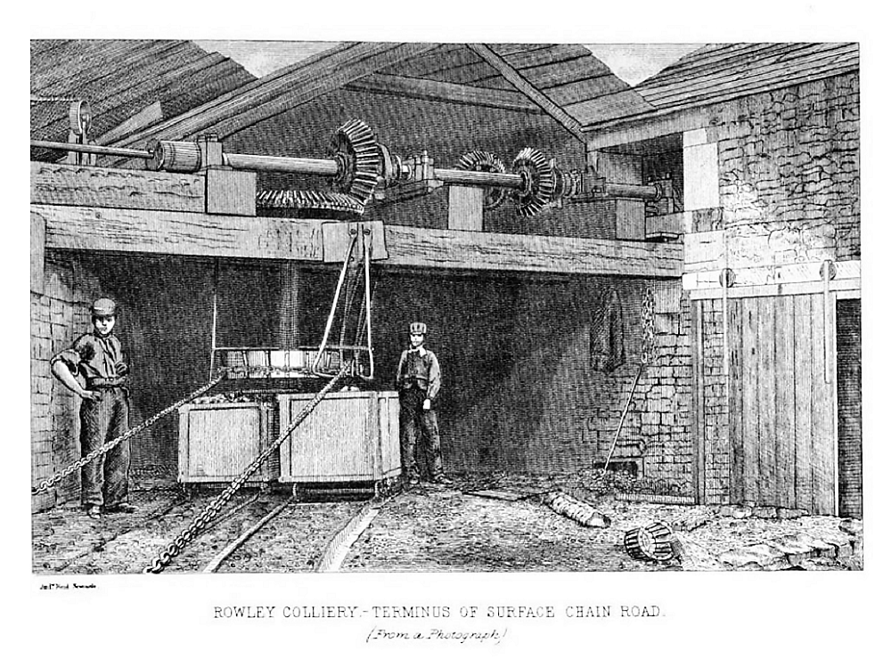 Most northerly portion of the Lancashire Coalfield, surrounding Burnley, Nelson, Blackburn and Accrington. and to the south is the much larger South Lancashire Coalfield, which comprises, from west to east, the St Helens, Wigan, Manchester
 Part of the Lancashire Coalfield. Some easily accessible seams were worked on a small scale from the Middle Ages, and extensively from the beginning of the Industrial Revolution until the last quarter of the 20th century., and Oldham Coalfields. The Oldham Coalfield extends to the south and becomes the Cheshire Coalfield. The coalfield covers around 550 square miles (1,424 km2) extending from Stalybridge in the southeast to Ormskirk in the northwest and from Rainhill in the southwest to beyond Burnley in the northeast.[5] The south eastern part extends well into Cheshire, where significant mining took place around Poynton and Dukinfield. The area of the coalfield became heavily industrialised as new industries developed, attracted by the availability of fuel.[6] A small area around Todmorden in West Yorkshire is geologically part of the coalfield.[7] The redrawing of administrative county boundaries in 1974 resulted in almost all the South Lancashire Coalfield lying outside the modern-day boundaries of Lancashire. A quite separate and much smaller coalfield is situated in the Wenning Valley in the northeast of the county but is part of the Ingleton Coalfield, the main part of which is in North Yorkshire.[8]
History
The Romans may have used coal in Lancashire, but the earliest written record of “minera” was made in 1246 when Adam de Radcliffe stole coal belonging to Adam son of Alexander. Small amounts of coal were dug during the Middle Ages, but wood was plentiful and turf was preferred to coal, which was inferior in quality. Coal was used for lime burning and by smiths.[9] Coal was got in Shakerley in 1429 when a dispute over the stealing of “seacoals” was recorded. Pits were small and shallow and Wigan and its neighbourhood were noted for numerous cannel Type of bituminous coal. pits that could be accessed from under property.[10] John Leland visited Haigh in 1538 and observed that “Mr Bradshaw … hath founde moche Canel like Se coal in his grounde very profitable to him.”[b]Mr Bradshaw has found much cannel coal in his land which was very profitable. Mining was not a full-time occupation: frequently the work was seasonal and combined with other occupations such as farming or weaving.[11]
During the Elizabethan era pits were sunk throughout the coalfield, at Haslingden, Padiham, Ightenhill and Trawden.[14][12] More than 50 small pits operated around Rochdale where coal was got in the 1580s at Falinge, Cronkeyshaw and near Littleborough. Shallow pits at Bradford Bradford Colliery was a coal mine in Bradford, Manchester, England., a little over a mile from Manchester town centre, produced enough coal for the town in the early 1600s.
Different areas of the coalfield expanded and contracted at different times. The Wigan area, with coal relatively close to the surface, was important by the 18th century, fuelling the brass and pewter industries; and after the onset of the Industrial Revolution, cotton and heavy engineering. The coalfield around St Helens developed from the mid-18th century supplying the copper, glass and chemical industries that developed close to the Sankey Canal.[13]
In the 1770s records show there were pits in Wigan, Bolton, Oldham, Ashton-under-Lyne and Dukinfield. From the 16th and 17th centuries some landowners began to develop the industry, and dynasties of coalowners emerged included the Bradshaws and Earls of Crawford and Balcarres of Haigh Hall, the Hultons of Hulton Park, the Fletchers, the Knowles and the Duke of Bridgewater and his successors the Bridgewater Trustees. Companies that emerged during the 19th century included Richard Evans and Company of Haydock Collieries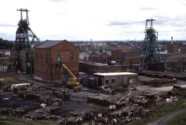 Haydock Collieries comprised several pits, some started in the 18th century, on land owned by the Leghs of Lyme around Haydock on the Lancashire Coalfield in north-west England., which originated in 1830. Pearson and Knowles Coal and Iron Company was formed in 1874 in Ince. Colonel John Hargreaves began a company with pits in Burnley, and George Hargreaves owned pits in Accrington and Rossendale. James Lees’ Chamber Colliery Company owned pits in Oldham.[14]
Developments
In 1600 coal was dug from outcrops and shallow bell or ladder pits where roof falls were common. Drainage was a problem and many workings were abandoned. Roger Bradshaw dug the Great Haigh Sough, Tunnel or adit driven under Sir Roger Bradshaigh’s Haigh Hall estate between 1653 and 1670, to drain his coal and cannel pits. a 1,120 yards (1,020 m) long tunnel, under his Haigh Hall
 Historic country house in Haigh, near Wigan in Greater Manchester England. estate to drain his pits into a nearby stream between 1653 and 1670.[15] Other soughs were dug, including one in 1729 to drain the Worsley mines
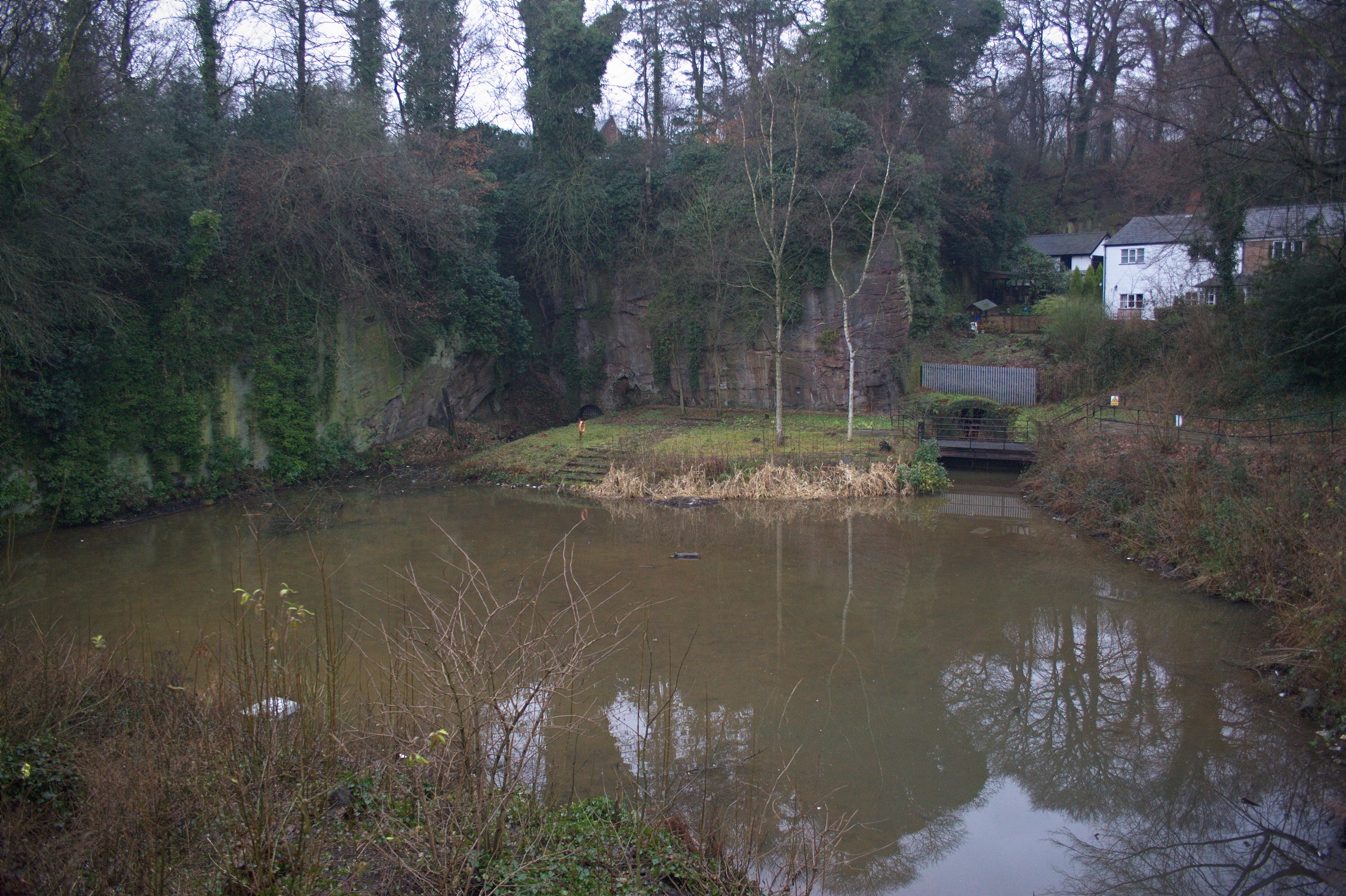 Extensive network of underground canals that drained the Duke of Bridgewater's coal pits emerge into the open at the Delph in Worsley, Greater Manchester. and another from Standish Colliery to the Leeds and Liverpool Canal at Crooke. A waterwheel was used from 1720 to lift water from the workings of the Plumbe Street Mine in Burnley using an endless chain of buckets, and James Brindley installed a waterwheel at the Wet Earth Colliery in the Irwell Valley.[16]
The invention of steam engines, first in 1698 by Thomas Savery and then in 1711 by Thomas Newcomen, provided an alternative method of draining wet mines and winding men and coal from deeper pits.[17] A Newcomen-type atmospheric engine installed at Bardsley Colliery in Ashton-under-Lyne in about 1760 was known as Fairbottom Bobs Fairbottom Bobs, an 18th-century Newcomen-type beam engine, was used to pump water from a coal pit near Ashton-under-Lyne, is probably the world’s second-oldest surviving steam engine..[18]
In 1720 the River Douglas near Wigan and the Rivers Irwell and Mersey were made navigable, providing a more efficient and cheaper method of transporting coal. The Sankey Canal was constructed in 1755 and by 1760 Francis Egerton, 3rd Duke of Bridgewater was constructing the Bridgewater Canal, providing a direct link from the Worsley Navigable LevelsExtensive network of underground canals that drained the Duke of Bridgewater's coal pits emerge into the open at the Delph in Worsley, Greater Manchester. into Manchester. More canals were constructed including the Leeds and Liverpool and Manchester Bolton & Bury Canals.[19][20]
The Bolton and Leigh RailwayLancashire's first public railway, promoted as a mineral line in connection with William Hulton's coal pits to the west of his estate at Over Hulton., Lancashire’s first public railway, opened in 1828 to carry coal and cotton. It passed to the west of William Hulton’s estate and gave his pits at Chequerbent access to Bolton and Liverpool. In the following 20 years the main lines of the railway system were constructed, linking the increasingly industrial towns in Lancashire with the rest of the country.[21] Access to transport, the steam engine, the development of the textile industry with raw cotton imported through the Port of Liverpool and associated industries led to increased demand for coal and larger, deeper mines.
Conditions
At the turn of the 19th century demand for coal increased rapidly for domestic and industrial consumption. Miners worked in intolerable conditions, coal was got by hewers using picks and shovels in mines lit by candles. Children as young as five sat in complete darkness opening ventilation doors for “hurriers”, the women and boys who hauled tubs of coal to the shaft bottom. Some coalowners used the bond system to enforce discipline and prevent workers from joining together to fight for better pay and conditions.[22] The Combination Acts Acts of Parliament passed by the Tory government of William Pitt the Younger in response to its fear of unrest or revolution among the working classes. They banned workers from combining to form trade unions and prevented them from striking, calling for shorter hours or increased pay. of 1799 made unions illegal. Some coal owners paid their miners with tokens that could only be redeemed in their company shops, a practice outlawed by the Truck Act 1831.[23] The Duke of Bridgewater paid eight shillings (40p) for a six-day working week with shifts of 12 to 15 hours and fined those who were late half a crown.[24] The wages amounted to a few pence more than Poor Law relief and miners worked to keep out of the workhouse
 Establishment where the destitute in England and Wales received board and lodging in return for work.. William Hulton
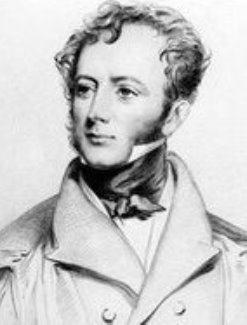 Landowner who lived at Hulton Hall in Lancashire, notorious for his part in the Peterloo Massacre. reputedly paid the poorest wages in Lancashire and was hostile to permitting his workforce the right to free assembly.[25]
The Mines Act of 1842 Act of the Parliament of the United Kingdom prohibiting all females and boys under ten years of age from working underground in coal mines. prohibited women and girls and boys under the age of ten from working underground in coal mines. After 1842 women continued to work on the surface, sorting coal from dirt on the coal screens, as pit brow lasses
 Female surface labourers at British collieries. They worked at the coal screens on the pit brow (pit bank) at the shaft top until the 1960s. Their job was to pick stones and sort the coal after it was hauled to the surface..[26]
20th century
In 1907 coal was produced largely by hand in the coalfields 358 collieries and and pit ponies used for haulage. The highest annual tonnage, more than 26 million tons was produced in 1907.[10] During the first quarter of the 20th century an average of nearly 20 million tons of coal was produced annually by a workforce of 100,000 men. Conditions became increasingly difficult as the best, most easily won coal was worked out. In the Burnley area output from the thin seams towards the north of the coalfield was small. Despite its higher price Lancashire coal remained important. Consumption was largely for the local market but some was shipped abroad. Manchester was the centre of a vast industrial district and there was a great demand for coal from the cotton industry, engineering, iron and chemical works, and other industries. Demand for coke in the foundries had led to coke-ovens being built next to some collieries. Steam coal was required for cotton mills, chemical works, engineering works, and locomotive fuel, house coal had a large market in a heavily populated area.[14]
In 1927 there were 222 working collieries belonging to 125 owners. The 18 pits in Cheshire had 15 owners. Most companies were small: more than 100 pits had fewer than 200 workers while 60 pits employed more than 200, 14 employed between 1,000 and 2,000, and 18 more than 2,000 workers.[14]
The Mining Industries Act of 1925 attempted to stem the post-war decline and encouraged independent companies to merge in order to modernise and better survive the prevailing economic conditions. Robert Burrows of Atherton’s Fletcher Burrows CompanyOwner of collieries and cotton mills in Atherton in North West England. proposed merging several companies operating to the west of Manchester and in March 1929, Manchester Collieries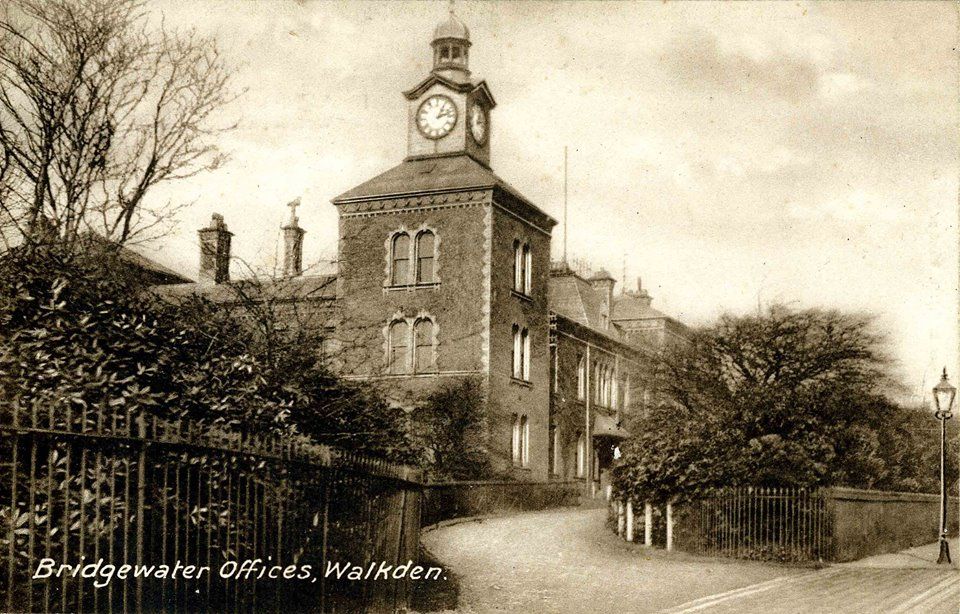 Coal mining company with headquarters in Walkden, Lancashire, formed in 1929 by the merger of a group of independent companies operating on the Manchester Coalfield., the largest such company on the coalfield was formed.[27]
Nationalisation
On the vesting date, 1 January 1947, the country’s coal mines were nationalised and the service contracts of the employees transferred to the National Coal Board Statutory corporation created to run the coal mining industry in the United Kingdom under the Coal Industry Nationalisation Act 1946. (NCB).[28] The coalfield’s 86 collieries were nationalised and the coalfield divided into four areas, Manchester with 20 pits, Wigan had 26, St Helens 22 and 18 in BurnleyMost northerly portion of the Lancashire Coalfield, surrounding Burnley, Nelson, Blackburn and Accrington. but the number of collieries declined as reserves became exhausted.[29]
To maximise coal output, short-life drift mines including Fence Drift and Wood End Drift near Burnley and Seneley Hall Drift at Standish and Dairy Pit at Haigh opened in the early 1950s. At the same time, the NCB embarked on extensive programmes of boring to prove the reserves of coal and modernised collieries. In the late 1950s smaller collieries were closed in the Wigan and Burnley areas as was Deane Colliery in Bolton.[30]
Production at the reopened Agecroft Colliery resumed in 1960, and by 1962 major investment at Mosley Common Colliery turned it into a “superpit” at a cost of £7.5 million. The last shafts to be sunk on the coalfield were at Parkside Colliery in Newton-le-Willows. Sinking to the Crombouke and Lower Florida seams at a depth of 886 yards started in 1957 and production began in 1964.[30]
In the 1960s the NCB began closing collieries, some with workable coal reserves, by setting impossible production targets and by 1967 just 21 pits remained. The Mosley Common superpit closed in 1968[31] and Astley Green closed in 1970, both had huge reserves of coal. The remaining collieries closed after the 1984 miners’ strike, Bold Colliery in St Helens closed in 1985, Agecroft in 1991 and the Bickershaw, Golborne, Parsonage complex a year later. Parkside Colliery, the last deep mine on the coalfield, closed in 1993 without exhausting its coal reserves.[30]
Disasters
Gassy coal seams, poor ventilation and the use of candles meant the coalfield was prone to explosions and disasters Mining disasters in Lancashire in which five or more people were killed occurred most frequently in the 1850s, 1860s and 1870s. and, between 1851 and 1853, Lancashire had the highest mortality rate of any British coalfield. In 1850, 16 men and boys died at Bent Grange Colliery in Oldham, 36 died at Coppull Colliery in 1852 and in two disasters within a year at Ince Hall Colliery, 58 died in 1853 and 89 men died in 1854.[32] In 1883 some 68 men and boys were killed and 53 were injured at Moorfield colliery near Accrington. In 1859 there were 68 fatal accidents in Manchester district and 57 in Wigan and St Helens. The third worst mining disaster in the country was at Hulton Colliery Company’s
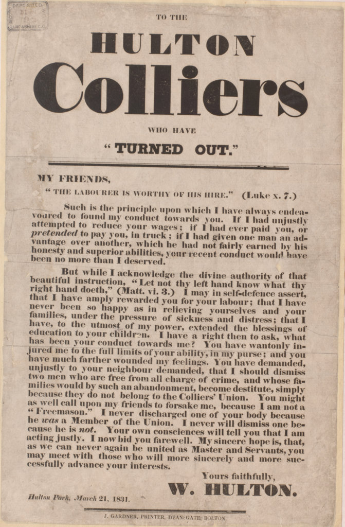 The Hulton Colliery Company operated on the Lancashire Coalfield from the mid-19th century in Over Hulton and Westhoughton, Lancashire. Pretoria Pit in 1910 when a faulty lamp caused an explosion killing 344 miners.[33] In 1962, 16 men died and 21 were injured at Hapton Valley Colliery near Burnley. The last disaster was at Golborne Colliery in March 1979, when three men died instantly in an explosion of methane caused by an electric spark and seven men later died of their injuries.
The Lancashire and Cheshire Coal Owners Association decided to provide a mines rescue Specialised job of rescuing miners and others who have become trapped or injured in underground mines because of accidents, roof falls or floods and disasters such as explosions caused by firedamp. station at Howe BridgeFirst mines rescue station on the Lancashire Coalfield, opened in 1908 in Lovers Lane Howe Bridge, Atherton, Lancashire. in Atherton to attend accidents and disasters in their pits in 1908.[34] It was replaced by Boothstown Mines Rescue Station
 Mines rescue station serving the collieries of the Lancashire and Cheshire Coal Owners on the Lancashire Coalfield, opened in 1933. close to the East Lancashire Road in 1933. It replaced four smaller stations and was permanently staffed by two rescue teams who attended emergencies across the entire coalfield.[35]
Unions
Colliery owners fended off the formation of unions until well into the 19th century and trade unionism was slow to take a hold on the coalfield. Employers arbitrarily fined men for minor reasons, disallowed wages on false pretexts and victimised perceived radicals. Bonds were used to enforce discipline. Miners protested about poor wages in 1757 when bread prices rose and some marched from Kersal towards Manchester in protest but were turned back. When trouble flared, the Home Secretary ordered troops to be ready to quell the unrest. Long strikes were unsustainable as the miners had no organisation or finances to back them up. The first miners’ association, the “Brotherly Union Society” was formed in Pemberton in 1794. It was described as a friendly society to avoid prosecution under the Combination Acts; by the early 19th century there were twenty-one such societies in central Lancashire.[36] The Lancashire and Cheshire Miners’ Federation Trade union founded in the aftermath of a bitter and violent seven-week strike in 1881. (LCMF) was founded in 1881 after a bitter and often violent seven-week strikeBitter and violent Lancashire miners' strike of 1881 that lasted for seven weeks, and ended with no resolution. and after the formation of the National Union of Mineworkers in 1945, the LCMF became its Lancashire area. Though not considered militant, the union was involved in several strikes, including the national strikes of 1926, 1972, 1974 and 1984.[31]
Legacy
There can be no doubt that coal mining substantially changed the landscape. The Victoria County History has several disparaging descriptions of the Wigan area in the early 20th century.
Hindley lies in the centre of the great Lancashire coalfield, and consists of a level-surfaced country dotted over with collieries and black pit-banks. A close network of tramways and railways covers the face of a singularly dreary stretch of country, where the pastures are scanty and blackened. Frequent pools of water lie between the collieries, indicating subsidences of the earth caused by mining. What trees remain standing appear as dead stumps, with leafless branches reflected weirdly in the “flashes” of water.[37]
Notes
| a | In Lancashire a coal seam is referred to as a mine and the coal mine as a colliery or pit. |
|---|---|
| b | Mr Bradshaw has found much cannel coal in his land which was very profitable. |

