

Common Fold in Shakerley
Wikimedia Commons
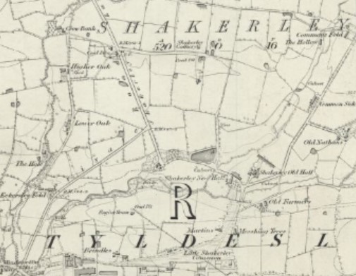
Shakerley, a suburb of Tyldesley Former industrial town in the Metropolitan Borough of Wigan, in Greater Manchester. in the Metropolitan Borough of Wigan, Greater Manchester was anciently a hamlet and scattered farms around Shakerley Old Hall in the northwest of the townshipDivision of an ecclesiastical parish that had civil functions.. The boundary between Shakerley and Atherton is the Hindsford Brook. Shakerley was separated from Tyldesley by the common and access was along Common Lane.
Shakerley was at one time the most populated and industrialised part of the township and its situation on the coal measures of the Lancashire Coalfield The Lancashire and Cheshire Coalfield in North West England was one of the most important British coalfields. Its coal seams were formed from the vegetation of tropical swampy forests in the Carboniferous period more than 300 million years ago. provided one of the raw materials needed for nail making. Farming and and domestic weaving were the other main occupations.
Geography
Shakerley covers 540 acres in the north western portion of the township of Tyldesley cum Shakerley,[1] separated from Tyldesley by Shakerley Common. The Hindsford Brook flowing north to south is the ancient boundary between Shakerley and Atherton. The Old Mill or Shakerley Brook flows east to west across the common meeting the Hindsford Brook at Hindsford Bridge on the Tyldesley-Atherton boundary. The area between these brooks is mostly flat and the underlying rocks are the coal measures of the Manchester Coalfield Part of the Lancashire Coalfield. Some easily accessible seams were worked on a small scale from the Middle Ages, and extensively from the beginning of the Industrial Revolution until the last quarter of the 20th century. covered with boulder clay.[1]
Shakerley is accessed by a single road that has a junction with the A577 on the border with Hindsford where Hindford Bridge crosses the brook.[1] A former toll road, Shakerley Lane, has been closed to traffic and is now a bridleway and footpath.[2] The Lancashire and Yorkshire Railway’s line from Manchester to Southport passes through the north of Shakerley and Atherton is the nearest station.
History
Shakerley’s name is derived from the Old English sceacere and leah meaning the robbers woodland glade or clearing. It was recorded as Shakerlee in 1210.[3] The ending “ley” denotes the area was once cleared of forest. Two old house names, “Higher Oak” and “Lower Oak”, refer to the oak forest that once covered the area. Hindsford Brook, once the Goderic Brook, was named after a Saxon saint.[4]
The Roman road from Mamucium (Manchester) to Coccium (Wigan) passed through the hamlet south of Shakerley Old Hall.[5]
Reproduced with the permission of the National Library of Scotland
The hamlet grew close to the brook and the Roman road in the Tyldesley cum Shakerley township in the ancient parish of Leigh.[4] The family who lived at Shakerley Old Hall took their name from the hamlet. Hugh Tyldesley endowed Cockersand Abbey Founded as a hermitage before 1184, the remains of which are now a scheduled monument. with land in Shakerley in the early-13th century and the Shakerleys paid rent to the canons of the abbey and dues to the Tyldesleys.[1][7] After acquiring property in Cheshire, the Shakerleys migrated to Cheshire in about 1520 but retained ownership of the estate.[1] The last of the family to live at the old hall, Hugh, was buried in Leigh and the hall was let to tenants.[8]
In 1646 the Royalist, Geoffrey Shakerley, was fined and his lands were sequestrated for his support of King Charles I. They included Shakerley Old Hall, land, the corn mill, and five nail smithies.[9] In 1667 Shakerley Old Hall was a magnificent home containing the hall, cellars, brewhouse, buttery, dairy, dining room, parlour and various chambers. By 1742 it was home to a succession of tenant farmers.[10]
The corn mill was recorded in 1656. Henry Hindley, miller at Shakerley died in 1697.[11] In 1785 the mill was let to Joseph Adkin. By 1811 it had been converted into a carding and spinning shed. After that it was converted to cottages that lasted into the 20th century.[12] William Mather was recorded in as an innkeeper in 1696.[13] In 1748 Shakerley was the most populous and industrialised part of the township.[13]

Wikimedia Commons
The absent landlords, the Shakerleys sold the estate in 1836. The sale included farms and land totalling 514 statute acres with “valuable mines of coal and stone lying under the same”. It was bought by Jacob Fletcher of Peel Hall, Little Hulton.[14]
The Shakerley estate was broken up in 1951. The farms, Old Shams on Shakerley Lane, Greenfield, Eckersley Fold and Common Fold were sold and Tyldesley Urban District Council acquired Shakerley Common and land for housing. Over the next thirty years a large part of Shakerley was developed for social housing.[15]
Heretic
A nailor, Jeffrey Hurst, influenced by his brother-in-law George Marsh Protestant priest who became a martyr, after his execution in 1555 as a result of the Marian Persecutions during the reign of Queen Mary I. of Deane, brought religious dissent to Shakerley. Travelling preachers held meetings in his house. After Mary I ascended the throne in 1553, the Marian Persecutions began but Hurst persisted preaching the Protestant faith. He refused to attend mass and for safety fled into Yorkshire but returned after his father died. A warrant for his arrest was issued and Thomas Leyland of Morleys Hall
 Moated hall converted into two houses on the edge of Astley Moss in Astley, Greater Manchester, England, largely rebuilt in the 19th century on the site of a medieval timber house. accompanied by his chaplain rode to Shakerley. They searched Hurst’s mother’s house and found nothing but Latin grammars and a Tyndale Bible. Hurst’s mother and brother had to guarantee that the “heretic” would appear before him at Morleys which he did after three weeks. He was sent to be tried at Lancaster Castle but Mary died in November 1558, saving him from the martyrdom that George Marsh suffered at the stake at Chester in 1555.[16]
John Wesley visited Shakerley four times: in May 1748,[1] October 1749, April 1751 and June 1752. Religious dissent again took hold and in 1770 a house had been authorised for meetings.[13]
Industry
Nailors
Nail making was an important industry in Shakerley and neighbouring Chowbent.[a]Atherton Nailmaking was a guilded craft with special rules. Apprenticeships lasted from four to seven years. Ellis Astley’s will of 1584 specified that when the apprentice had finished his indentures he would receive 6/8d and a piece of iron from his master.[17]
At least five tenants of the Shakerleys , including the Astleys and the Aldreds, had smithies and made good livings from the trade.[18] Thomas Higginson, son of a Shakerley nailor, graduated from Cambridge University in 1648.[19]
Coal

An armed dispute between the Shakerleys and the Tyldesleys arose over the digging of “seacole” in 1429.[20] A colliery on Shakerley Common owned by John Hope of Chaddock Hall in 1798 was acquired by Fletcher when he bought the estate in 1836. In 1853 the owner was Nathan Fletcher.[13]
Ramsden’s Shakerley CollieriesRamsden’s Shakerley Collieries was a coal mining company operating from the mid-19th century in Shakerley, Tyldesley in Lancashire, England. included the Wellington[b]Messhing Trees and Nelson[c]Shakerley Pits. Nelson Pit was isolated from the road through Tyldesley and a cobblestone road, the Old Toll Bar Road,[d]Shakerley Lane was made across Shakerley to the Leigh to Bolton road near Green Hall in Atherton.[21] Tolls were collected until 1949 when the toll house was demolished. The Tyldesley Coal CompanyCoal company was formed in 1870 in Tyldesley on the Manchester Coalfield, in the historic county of Lancashire, England. had collieries at CombermereColliery sunk by the Tyldesley Coal Company on the Manchester Coalfield after 1867 in Shakerley, Tyldesley in Lancashire, England. and Peelwood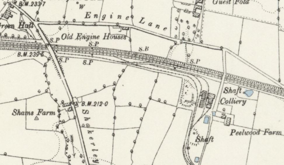 Peelwood Colliery on the Manchester Coalfield in Shakerley, Tyldesley, Lancashire, began producing coal in 1883.. A brickworks was built at Combermere after the pit closed.[22]
Notes
| a | Atherton |
|---|---|
| b | Messhing Trees |
| c | Shakerley |
| d | Shakerley Lane |

