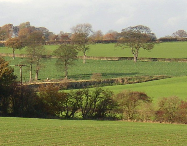
Remains of the viaduct on the Flockton waggonway Wikimedia Commons
The Flockton Collieries comprised several pits and adits, some started before 1700, in FlocktonRural village stretched out along the Barnsley to Huddersfield road in Kirklees, West Yorkshire, taking its name from a Viking settler. and Sitlington between Wakefield and Huddersfield in the West Riding of Yorkshire. The area in and around Flockton is underlain by easily-accessible coal seams and coal was accessed from the surface from shallow bell and ladder pits. Two coal seams, the Flockton Thick and the Flockton Thin were named from where they outcropped.
In the 17th century Richard Carter made his fortune from coal. As soon as the Calder and Hebble Navigation Constructed between 1758 and 1834, the navigation makes the River Calder navigable between Sowerby Bridge and Wakefield in the West Riding of Yorkshire. made cheap bulk transport available, Richard Milnes built a horse-worked waggonway to transport coal from his pits in Dial Wood to the Calder and Hebble Navigation at Horbury Bridge. James Milnes started pits at Lane End and Emroyd Common.
Geology
Flockton is located at the transition from the Lower Coal Measures in Kirklees to the Middle Coal Measures that are found towards Barnsley and Wakefield. Flockton village is built on a layer of sandstone, the Birstall Rock, of the Lower Coal Measures that are made up of layers of sandstones, mudstones, siltstones and coal seams. They are Carboniferous rocks formed 310 million years ago when they were deposited as sediments in large river deltas that extended into the shallow, tropical seas that covered much of Britain at this time. In the area, six coal seams were accessible at the surface for drift mining, and at shallow depths for early bell and ladder pits.[1] The pits had access to the Joan coal and Flockton Thick, Flockton Thin, Old Hards, Green Lane (Emroyd Silkstone), New Hards (Cromwell best), Wheatley (Wheatley Lime or Lime) and Blocking. The royalties for Flockton Thin and Thick were exhausted by the mid 1850s.[2]
Two coal seams were named from where they outcropped, the Flockton Thick, used for producing gas, oil and coke, which was up to 48 inches (122 cm), and the Flockton Thin, an excellent house coal, at about 15 inches (38 cm).[3][4] Some streams in the area where coal seams have been disturbed are orange coloured, indicating that water has permeated through a layer of iron rich rock known as siderite, and iron has leeched into the shallow groundwater.[1]
History
Iron ore was mined in the area from ancient bell pits worked by monks from Rievaulx and Fountains Abbeys in the 12th century.[1]
A coal pit at Flockton was recorded in 1515, and by the 1700s its shafts had reached a depth of 300 feet (91 m).[1] In the 17th century Richard Carter, who died around 1700, made his fortune from coal. He financed Flockton’s first church, almshouses and endowed the school.[5]
Richard Milnes (born around 1712), a timber merchant and maltster, who by 1764 was renting Flockton Manor,[3] began the family’s coal mining business on the Wortley’s New Hall estate in Dial Wood in neighbouring SitlingtonAncient township of four villages, renamed from Shitlington to Sitlington in 1929..[6] Flockton coal was sold locally until 1758 when the Calder and Hebble Navigation made the River Calder navigable above Wakefield.[5]
Waggonway
Richard Milnes started the wooden waggonway between his pits at Dial Wood, between Flockton and Middlestown, to the new navigation in 1772. Coal was transported to staithes on the navigation behind the Bingley Arms at Horbury Bridge.[a]This was the old cut which was replaced by the new cut in 1839 when the coal staithes were relocated to the new cut on the north side of the turnpike.[3][6] It reputedly cost £6,000.[3]
The three-mile (4.8 km) long wooden waggonway, described as a “Newcastle road”, was initially worked by horses and the steep section from Middlestown northwards towards the Smithy Brook was worked by a self-acting incline.[7] It was built at the same time as the Wakefield and Austerlands turnpike road.[3] On the later upper section, the line ran over a 20-arch viaduct that crossed boggy ground and passed through a tunnel.[8] The tunnel is about 300 feet long, 80 inches wide and 90 inches high.[9]Kaye’s Mineral LineStandard gauge mineral line built to serve the pits owned by the Lister Kayes of Denby Grange in West Yorkshire. was built over the tunnel in 1854.[10]
The waggonway was relaid with cast-iron rails on stone blocks with cast-iron chairs after 1816. Parts of the line were relaid with flat bottom rail by 1878, and a Manning Wardle F class locomotive ran on the lower section from Emroyd following the Smithy Brook towards four coal staithes on the navigation at Horbury Bridge; the railway had an unusual 3 feet 9 inch gauge. The vaulted tunnel and its entrance portal with rubble flanking walls is a Grade II listed structure.[11]
Milnes brothers
After Richard Milnes death in 1779, his son James and his three brothers inherited the business. The Flockton Thick at the site of CaphouseEx-colliery in Overton, near Wakefield, West Yorkshire, now the National Coal Mining Museum for England. was worked from shallow pits by James Milnes. He leased the mineral rights from Mary Wortley, the Countess of Bute in 1772. His colliery had 17 shafts about 200 yards (183 m) apart by 1791,[b]No 17 shaft was on the site of Caphouse Colliery and was worked out by 1803.[12]
Emroyd Colliery 1894[13] Reproduced with the permission of the National Library of Scotland
The Milnes brothers took out more leases from the Wortley estate and James Milnes leased a farm in Middlestown close to Caphouse.[c]Cap House is now the Reindeer Inn.[6] The leases were consolidated into a single lease in 1792. James Milnes also purchased a lease of coal in Flockton from Mrs Rhodes whose family had inherited Richard Carter’s property.[14] All the coal seams were consolidated in the lease, which also included the rights to drive a sough to drain his pits near Grange MoorTract of moorland more than 700 feet above sea level that gave its name to Grange Moor, a residential village. .
Thomas Blackett of Bretton HallCountry house on the north slope of the valley of the River Dearne in West Bretton near Wakefield, West Yorkshire, England. bought the Rhodes land in Flockton and Milner leased coal from Blackett in Flockton and Cumberworth.[15] The pits sunk on the Blackett land between Flockton Church and the Manor House and near the school had short working lives.[16]
James Milnes, independently of his brothers, leased coal at Emroyd Common in the north of Middlestown not far from the Smithy Brook from Sir George Armitage of Kirklees ParkMedieval nunnery associated with the legend of the death of Robin Hood. in 1796.[17] Here Milnes developed Emroyd Colliery.[18] His 31-year lease included the right to make railways. He leased the ironstoneNamed from its outcrop at Tankersley near Barnsley in South Yorkshire. rights for 29 years in 1798, and a year later he leased the land at Emroyd until 1827. A plan from 1801 shows nine ironstone pits and a furnace.[17]
By 1799 the Milnes brothers employed more than 200 men and boys, supplying coal to east Yorkshire via the navigation.[10]
New century
After James Milnes death in 1803 the company was run by his executors.[18] Milnes left more than £39,000 and disputes between his brothers and widow, Mary Ann, emerged. After a protracted disagreement, the brothers agreed to a sum of £300 each and Mary Milnes took control of the company. She had delegated the day-to-day management of the pits to John Bell who may have been a relative. Her daughter Margaret married William Stansfield in 1815 and Marianne married Henry Briggs in 1824. Stansfield and Briggs were both involved in running the business. Briggs left the company in the 1840s and it was then run solely by the Stansfields.[10]
Lane End Colliery 1894[19] Reproduced with the permission of the National Library of Scotland
The iron-smelting business was run by Milnes’ executors until 1814 when it was taken over by William Coe of the Dewsbury Ironworks in Thornhill Lees. Emroyd Common was described as “a piece of bad land covered with coal pit and ironstone hills” in 1825.[17] The Emroyd furnace was worked until 1835 but its ruins survived until 1958 when the site was opencasted.[20] At first the Emroyd coal pits worked the Old Hards at 61 yards (56 m) and the New Hards at 104 yards (95 m). [17] In the 1830s the tramway was extended along the Smithy Brook to Mugg Mill where the company had leased land and towards Lower Whitley.[18] Various other pits were sunk on the common including the Brothers Pit, and deeper seams were worked over the years.[17]
Lane End Colliery on the road between Flockton and Midgley was sunk before 1803 and linked to the waggonway.[15] It became the largest of the Flockton pits with access to eight coal seams from 15 inches (38 cm) to 33 inches (84 cm) in thickness. In 1843 the pit provided employment for 500 men and boys.
Flockton system
The Milnes, Briggs and Stansfield families were Unitarians and provided their employees with decent housing and wages. In what became known as the “Flockton system”, they also provided Sunday schools and a library, land for allotments and encouraged sporting activities. Flockton Collieries were visited by Commissioners reporting to Parliament regarding the employment of children in 1841 when boys and girls were employed hauling tubs underground. The commissioners singled out the company for its efforts in providing civilising influences.[18][21] Child labour was prevented by the passing of the Mines and Collieries Act 1842 Act of the Parliament of the United Kingdom prohibiting all females and boys under ten years of age from working underground in coal mines.
which also prevented women from working below ground.[22]
Decline
Despite being well run, in the mid-19th century, the company suffered from not having a connection to the growing railway network. The Leeds and Manchester Railway opened through Horbury Bridge in the 1840 but was separated from the waggonway by the River Calder and navigation.[21] Production declined towards the 1880s and Emroyd was nearly worked out. The company asked the Lancashire and Yorkshire railway to provide a connection to the line through Horbury, but circumstances conspired to prevent it.[23]
Captain Stansfield died in early 1893. Later that year, the miners joined a national miner’s strike against a 25 per cent pay cut, bolstered by a disaster at Combs Pit in neighbouring Thornhill and the Featherstone riot after troops fired into a crowd of strikers to keep the men out of the pits. Mrs Stansfield didn’t feel able to continue and gave up the leases in January 1894. The manager, John Wood, attempted to keep the company going but failed and the business closed. The colliery plant was advertised for sale in 1904, the rest having been auctioned in 1895.[23]
This was the old cut which was replaced by the new cut in 1839 when the coal staithes were relocated to the new cut on the north side of the turnpike.[3]
Historic England. Flockton Waggonway Tunnel and Entrance Portal Approximately Mid-Way between Junctions of Hardcastle Lane and the New Hall Farm, New Hall Approach.
Woodall, R. D. The Sitlington Story. Wakefield Council, 1977.
Cookie Consent
We use cookies to optimise our website and our service. By clicking on “All cookies”, you consent to us using all cookies and plug-ins as described in our Cookie policy.
Functional cookies
Always active
The technical storage or access is strictly necessary for the legitimate purpose of enabling the use of a specific service explicitly requested by the subscriber or user, or for the sole purpose of carrying out the transmission of a communication over an electronic communications network.
Preferences
The technical storage or access is necessary for the legitimate purpose of storing preferences that are not requested by the subscriber or user.
Statistics
The technical storage or access that is used exclusively for statistical purposes.The technical storage or access that is used exclusively for anonymous statistical purposes. Without a subpoena, voluntary compliance on the part of your Internet Service Provider, or additional records from a third party, information stored or retrieved for this purpose alone cannot usually be used to identify you.
Marketing
The technical storage or access is required to create user profiles to send advertising, or to track the user on a website or across several websites for similar marketing purposes.