

View over Sale Water Park
Wikimedia Commons
Sale Water Park is a 152-acre (62 ha) area of parkland in the Metropolitan Borough of Trafford in Greater Manchester. Opened in 1979 and owned by Trafford Council, it comprises a 52-acre (21 ha) artificial lake and its surrounding area, which includes Broad Ees Dole, a designated Site of Biological Importance. The water park lies in an area of the green belt running through the Mersey river valley between Sale and StretfordOne of the four major urban areas in the Metropolitan Borough of Trafford, Greater Manchester., between the river and the M60 motorway. The lake was formed in the 1970s by the flooding of a gravel pit excavated to provide material for the construction of an embankment raising the motorway 34 feet (10 m) above the River Mersey’s floodplain.[1]
The land occupied by the water park was formerly within the grounds of Sale Old Hall, which was demolished in 1920.[2] All that remains of the hall today is its dovecote, which has been restored and relocated to the nearby Walkden GardensPublic green space in Sale, Greater Manchester. .[3]
Sale Water Park provides recreational facilities, is a wildlife reserve, and forms part of the flood defences for the surrounding area of Trafford.
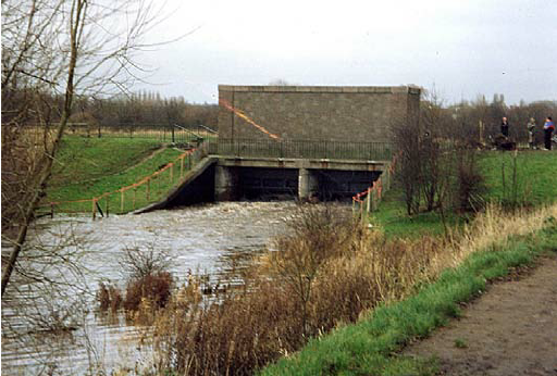
Flood mitigation
ResearchGate
If the water level of the River Mersey rises dangerously high, a sluice gate can be opened to allow water to flow from the river into the park, where it can be stored until the floodwaters have passed; the park is one of a number of similar flood basins in the area. Chorlton Water Park on the north side of the Mersey about one mile (1.6 km) upstream is another, along with areas in nearby Didsbury and elsewhere.[4]
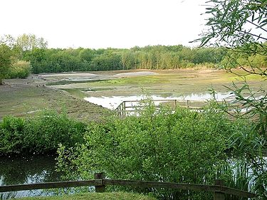
Broad Ees Dole
Wikimedia Commons
Major work was carried out in the 1980s to develop a plot of land to the east of the present lake, known as Broad Ees Dole, into a wetland area that could be managed to improve the wildlife value of the park, in particular for wild birds, the main lake being too deep to provide food for many bird species.[5] As a result, Broad Ees Dole was designated a Grade A Site of Biological Importance in 1988.[6][a]Grade A means that the site is considered to be of regional or county importance.[7] In 2003 it became the first site in Trafford to be recognised by English Nature as a Local Nature Reserve, largely because of its importance to migratory birds and the diversity of its plant life. There are no footpaths through the Dole, but those around the perimeter of the site provide excellent viewpoints.[5]
[xyz-ics snippet=”clear”]
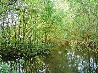
Wikimedia Commons
The woodland is a mix of alder, birch and willow, typical of the type that would have once covered the Mersey Valley. There is also an established orchid meadow, planted with heath spotted-orchids (Dactylorhiza maculata), and there are breeding colonies of smooth and great crested newts.[8]
The amount of water entering and leaving the Dole can be managed to maintain its mud flats, keeping them available for birds such as common snipe and little ringed plovers throughout the year. Migratory birds including redshank and common sandpipers also use the Dole as a resting and feeding place on their route north for the summer. In summer and winter, water can be allowed in to prevent the mud drying up; in spring and autumn, water can be released to expose the mud.[8]
The etymology of the name of this once pastureland perhaps provides a clue to one of its past uses. The term dole has been used historically to describe the common meadows shared out either annually or by lot, a meaning that persists in the idea of being “on the dole”, or receiving a handout.[9] The meaning of ees is less clear, but it has been suggested that it describes a wetland.[5]
Recreation
Trafford Water Sports Centre offers tuition in various watersports, along with equipment hire. The Boathouse Restaurant, situated by the side of the lake, is open throughout the day, offering drinks, snacks and meals. There is also a free car park for up to fifty vehicles,[10] and a nearby Metrolink tram stop.[11]