Wikimedia Commons
The Calder and Hebble Navigation, which made the River Calder navigable between Sowerby Bridge and Wakefield in the West Riding of Yorkshire, was constructed between 1758 and 1834. It is 27 miles (43 km) long and had two branch canals, the extant Dewsbury arm and another to Halifax that is now disused. The navigation begins at Fall Ings Lock in Wakefield, where it connects with the Aire and Calder Navigation at the start of Fall Ings Cut,[a]A cut is a man-made channel for a river or other waterway. and ends in Sowerby Bridge, where it meets the Rochdale Canal.
Halifax was connected to the main line after a branch canal from Salterhebble was authorised in 1825. It opened in 1828, and was abandoned in 1942.
Background
The River Calder rises in the Pennine hills above Todmorden, and flows in an easterly direction towards Sowerby Bridge and onwards through Elland, Brighouse, Mirfield, Thornhill Lees, Dewsbury, Horbury and Wakefield to Castleford, where it joins the River Aire. The Calder is joined by the Hebble Brook from Halifax at Salterhebble and the River Colne at Cooper Bridge. The Calder was made navigable from Castleford to Wakefield by the Aire and Calder Navigation in 1702.[1] The Calder and Hebble Navigation was planned to facilitate trade in the developing manufacturing towns upstream of Wakefield.[2]
History

Wikimedia Commons
An attempt to obtain an Act of Parliament to create a river navigation between Halifax and Wakefield was made in 1740. The route was surveyed by John Eyes of Liverpool using the Calder, the River Hebble and the Halifax Brook. It required the construction of twenty-one locks on the Calder and three on the Hebble and nearly 10 miles (16 km) of cuts, including one of 2 miles (3.2 km) at Horbury. The bill was defeated by opposition from landowners, mill owners and several turnpike trusts, who were intending to build roads along a similar route.[3]
In September 1756, after a meeting in Halifax, John Smeaton was asked to survey a route. In 1757 he produced a scheme to dredge shoals, make nearly 6 miles (10 km) of cuts, build 26 locks to overcome the rise of 178 feet between Wakefield and the Halifax Brook and construct a reservoir at Salterhebble Bridge. A committee raising finance for the planned Rochdale Canal insisted the navigation shold be extended to Sowerby Bridge where their canal would terminate. Despite opposition from the Halifax committee, the Act received Royal Assent.[4]
Wikimedia Commons
“An Act for extending the Navigation of the River Calder to, or near to, Sowerby Bridge, in the Parish of Halifax: And for making navigable the River Hebble, Halig, or Halifax Brook, from Brooksmouth to Salter Hebble Bridge in the County of York” passed in 1757.[2] In the early 1770s the waterway was completed to Sowerby Bridge.[1]
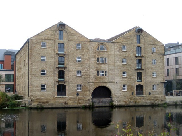
A branch canal links Double Locks at Thornhill to a basin at Savile Town in Dewsbury. Another branch canal from Salterhebble linked the main line to Halifax.[5] The canal is also connected to the Huddersfield Broad Canal at Cooper Bridge.[6] Trade in heavy cargoes such as Elland flagsSandstones interbedded with mudstones and siltstones in the Lower Coal Measures of West Yorkshire, once extensively quarried. from quarries opened at Cromwell Bottom and Elland Edge was facilitated by the navigation and coal was carried by rail on the Flockton tramwayFlockton Collieries comprised several pits, some started before 1700, around Flockton and Middlestown between Wakefield and Huddersfield in the West Riding of Yorkshire. for transhipping to east Yorkshire and beyond after 1770.[7] When completed, boats of 25 tons capacity could travel upstream from Wakefield to Sowerby Bridge.[2] Trade flourished and in 1804 the Rochdale Canal opened from Sowerby Bridge to cross the Pennines to Manchester.[1]
The company was most successful before the Manchester and Leeds Railway opened between 1839 and 1841. Its line parallels the Calder & Hebble and the Rochdale Canal. The railway company agreed to lease the canal for £40,000 per year for 14 years from March 1843 but the Aire and Calder Navigation objected and in April 1847 it was ruled it illegal. The Aire and Calder then offered to lease the canal from the September.[8] After that lease expired in 1885, the Navigation Company again took charge, rebuilt many bridges and established the Calder Carrying Company. Shareholders received dividends until the canal was nationalised in 1948, and the canal was used by commercial traffic until 1981.[9]
Although commercial traffic had mostly ceased by 1955, apart from coal which was carried to Thornhill power station until 1981, the Calder and Hebble remained open for leisure use. The re-opening of the Rochdale Canal to Manchester in 2002 increased traffic along the navigation which is part of the South Pennine Ring.[10]
Construction

Wikimedia Commons
Construction started in November 1759,[11] with Smeaton as engineer.[12] The navigation was open to Brighouse, 16 miles (26 km) from Wakefield by November 1764. James Brindley took over from Smeaton in 1765 and the scheme was almost completed when serious floods in October 1767 and February 1768 caused serious damage. The Commissioners re-appointed Smeaton in 1768, to complete the work. Banks were repaired and floodgates built at the start of some cuts. Just as work was completed, another flood caused so much damage that the navigation had to close.[13] The commissioners had spent £64,000, most of which had been borrowed, and a second Act of Parliament was required to complete the work. The Act was obtained in April 1769. It created the Company of Proprietors of the Calder and Hebble Navigation. All the loans from 81 people who had subscribed to the original scheme were converted into £100 shares. More shares could be issued, and the company was able to borrow up to £20,000 using future tolls as security.[2] Construction of the initial phase was finished in 1770,[12] at a total cost of around £75,000.[14]
Developments

Wikimedia Commons
Problems with the water supply to the Sowerby Bridge pound were addressed by Smeaton who suggested a tunnel from Hollins Mill and construction began in June 1772, and completed in March 1794.[15] A new cut between Shepley Bridge and Mirfield was started in December 1775 supervised by William Jessop, and water levels were raised to allow boats to carry additional cargo in 1776. A new cut at Brighouse was made in 1780 and two staircase locks at Salterhebble and the single lock at Brooksmouth were replaced by three new locks in 1782.[16] A long cut at Thornhill to bypass Dewsbury was made in 1798 but a wharf and warehouse at Savile Town Basin in Dewsbury was not made until 1877. A cut and a lock were made near Brighouse at Brookfoot between 1805 and 1808, and the Elland cut was extended to the Sowerby cut in 1815.[17] Fall Ings Lock was replaced and Fall Ings Cut and a pair of locks opened in 1812. The work was jointly funded by the Aire and Calder Navigation Company in 1806.[18]
The company continued making longer cuts to bypass more sections of river and when the Aire and Calder Company rebuilt its main line, the Calder and Hebble sought another Act of Parliament to effectively abandon the river. The plans were opposed and modified and the Act of 1834 authorised larger new cuts and new locks of 70 feet by 18 1⁄2 feet. The Huddersfield Broad Canal pressed for the locks to be extended.[19] The new Horbury Cut between Broad Cut and the Figure of Three locks included two large locks and a new large lock beside the old one at Thornes opened in 1838, but little more was done, despite the Rochdale Canal also pressing for longer locks.[20] Hartley Bank CollieryFormer colliery in Netherton, West Yorkshire, opened in 1841 and closed in 1968. was sunk south of the Horbury Cut in 1841 and staithes were built to move coal.[21]
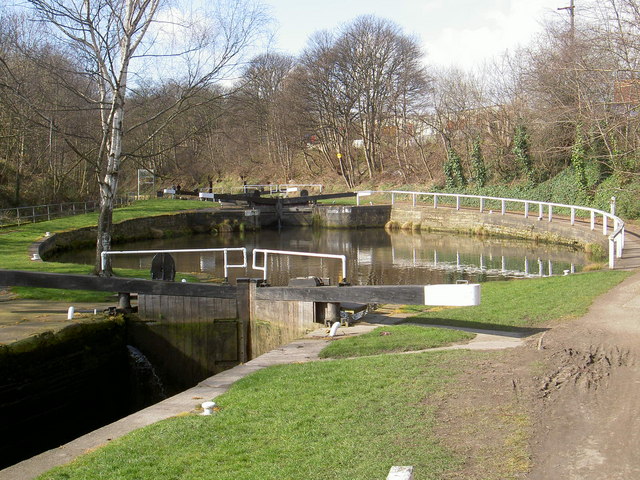
Locks
Most locks on the navigation above Broad Cut Lock are 57 feet 6 inches long and 14 feet wide.[22] The lock gates require a special handspike to operate the paddle gear. Some original paddle gear has been replaced but several locks cannot be operated without a hand-spike. They can be made from a three feet long piece of 4″ x 2″ or 3″ x 2″ hardwood and tapered to about 2¼” x 1¾” or bought at local boatyards.[23] The maximum size for boats that can navigate the Calder and Hebble is 54′ 2″ long with a 14′ 2″ beam, 4′ 11″ draught and 8′ 7″ in height.[24]
Halifax Branch
Halifax was reached after another Act of Parliament was obtained in March 1825 to raise £50,000[2] to construct the 1.75-mile (2.82 km) branch along the Hebble, from Salterhebble to near the railway station.[10] Halifax is 100 feet (30 m) higher than the navigation at Salterhebble,[25] and the branch had 14 locks.[26] It was supplied with water via a 1170-yard (1,070 m) long tunnel from Salterhebble to a pit near the top lock, from where a steam engine pumped water to the top pound.[2] The branch opened in 1828, having cost £58,741,[25] and was abandoned in 1942.[26]
Notes
| a | A cut is a man-made channel for a river or other waterway. |
|---|