Wikimedia Commons
Christopher Saxton (c. 1542 – c. 1610) was an English cartographer who produced the first county maps of England and Wales. He was born at Sowood near Wakefield and his family moved to Dunningley, a hamlet Rural settlement smaller than a village. near Woodkirk in the West Riding of Yorkshire. He was a student at Cambridge University and learned cartography from the Vicar of Dewsbury and Thornhill, John Rudd.
Saxton began his survey of England in 1574 and Wales in 1577. The first county plates were engraved by 1574 and completed in 1578. They were made into an atlas. In later life Saxton surveyed several local estates and at least twenty-five estate maps and fourteen written surveys are known. He produced surveys in Southwark and for private landowners in Yorkshire and Lancashire.
Life and family
Saxton was probably born at Sowood in Ossett in the parish of Dewsbury, in the West Riding of Yorkshire in either 1542 or 1544. His family subsequently moved to the hamlet of Dunningley near Tingley in the parish of Woodkirk where the Saxton name is recorded in 1567.[1] It is speculated that Saxton may have attended the predecessor school to Queen Elizabeth Grammar School, Wakefield and also speculated that he was a student at Cambridge University but neither is corroborated.[2] It is most likely that John Rudd, the vicar of Dewsbury and Thornhill, a keen cartographer, passed his skills on to Saxton.[3]
Saxton married and had three children. Robert, born in 1585, was his father’s assistant in 1601 and drew a map of Snapethorpe in Wakefield when it was surveyed by his father. Robert was commissioned to survey Sandal Magna in 1607.[4] Christopher Saxton died in either 1610 or 1611.[5] He may be buried at Woodkirk in Yorkshire, not far from his birthplace.[6]
Career
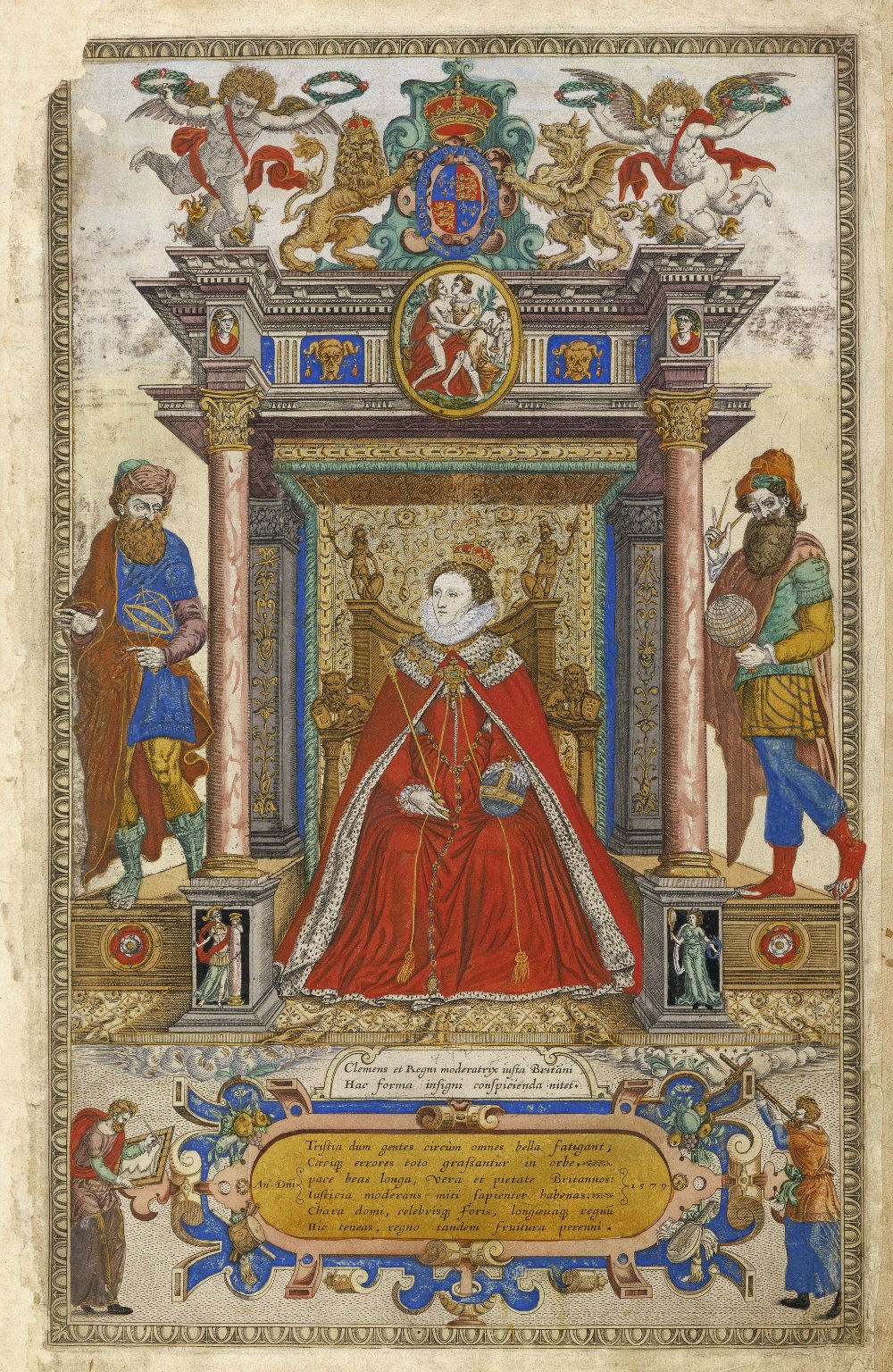
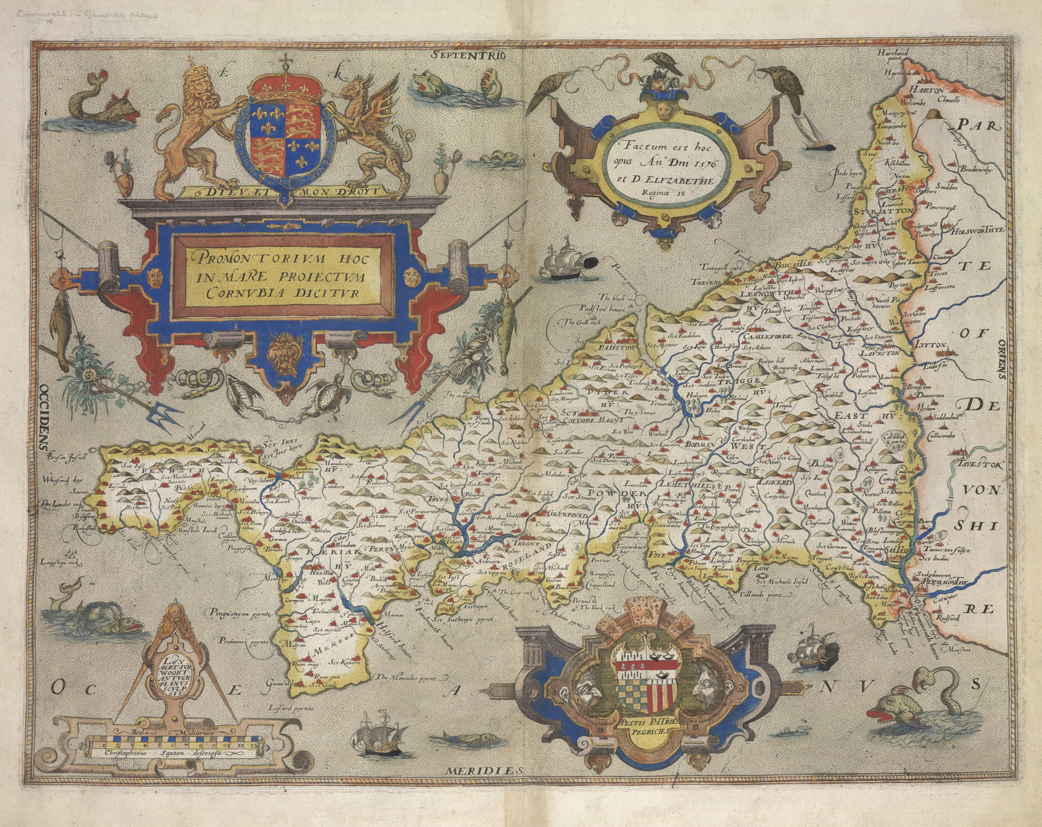
Map-making developed rapidly in the reign of Elizabeth I, made possible by advances in surveying technology and printing from engraved copper plates. Accurate mapping of the whole country became increasingly important. Lord Burghley was instrumental in ensuring that a court official, Thomas Seckford of Woodbridge, Suffolk, financed the commission of a survey of the English and Welsh counties.[7] In 1574 Saxton began the survey of England.[8] In consideration of the expenses involved, Queen Elizabeth granted him a lease on lands at Grigstone Manor in Suffolk. The Welsh survey began in 1577.[9] Surveying the country was a significant undertaking but the first plates were engraved by 1574 and in 1578 the survey was complete;[10] as the task was finished in a short timespan, Saxton may have used some of John Rudd’s earlier work.[7] Individual county sheets were issued before the completed survey was issued as an atlas in 1579. The proofs were presented to Lord Burghley, who compiled them into an atlas of his own.[10]
Wikimedia Commons
The maps were reproduced in the Atlas of the Counties of England and Wales, published in 1579, the first atlas of any country. It contained thirty-five maps, each bearing the arms of Elizabeth I and Thomas Seckford, Saxton’s patron. The maps show hills and mountains but do not provide precise information as to their location or altitude. A variety of symbols show buildings and settlements.[10] All the maps are dated except for Northumberland. Five counties, the Cornwall, Essex, Hertfordshire, Suffolk and Norfolk maps show the division into hundredsAdministrative subdivision of a shire..[11] The atlas was a commercial success, prompting other cartographers including John Speed, John Norton, and Michael Drayton to attempt similar enterprises, adding to and adapting Saxton’s work.[6]
The maps drawn by Saxton were engraved by Augustine Ryther, Remigius Hogenberg, William Hole, William Kip, Leonard Terwoort of Antwerp, Nicholas Reynold of London, Cornelius Hogius, and Francis Scatter. The engravers were of Dutch or Flemish origin.[7] There is no evidence on the maps that Saxton engraved them himself, but according to one account, he engraved those of the Welsh counties and Herefordshire. Saxton obtained a license to sell the maps for a term of ten years.[6]
Saxton surveyed several local estates in his later years. At least twenty-five estate maps and fourteen written surveys have survived. He produced surveys for the governors of St Thomas’s Hospital in Southwark and private landowners. In 1598 he surveyed Old Byland in Yorkshire for evidence relating to a boundary dispute.[6] John Dee, warden of the Manchester’s Collegiate Church,[a]Manchester Cathedral employed him to survey Manchester’s parish boundaries in 1596, but no copy has survived.[12] Chetham’s Library in Manchester has a copy of the atlas.[13]
Saxton’s maps put English cartography at the forefront of European map making. Other mapmakers soon adopted his outline of Britain; his county maps were revised by John Norden, and influenced the maps made by John Speed. Saxton’s maps were the “master geographical representation” of England and Wales until the Ordnance Survey published one-inch maps in 1801.[6]
Notes
| a | Manchester Cathedral |
|---|

