

Wychavon shown within Worcestershire
Wikimedia Commons
Wikimedia Commons
The local government district of Wychavon is one of the six local government authorities that make up the ceremonial county Area in England with an appointed Lord Lieutenant to represent the monarch's interest. of Worcestershire.[1] The borough contains forty-six of the Grade I listed buildings
 Structure of particular architectural and/or historic interest deserving of special protection. in the county.
Grade I structures are those considered to be “buildings of exceptional interest”.[2]
| Name | Location | Architect | Completed | Entry number | Image |
|---|---|---|---|---|---|
| 53 and 54 incorporating Remains of Abbey Gate (Abbey Gate House) | Evesham | Early 14th century | 1156720 | ||
| Abbey Church of Holy Cross with Saint Edburgha | Pershore Arndale centre built on the site of Stretford's original shopping centre, the former King Street. Arndale centre built on the site of Stretford's original shopping centre, the former King Street. | 11th to 13th century | 1387027 |  Wikimedia Commons | |
| Abbot Reginald’s Gateway | Evesham | c. 1120 | 1081349 |  Wikimedia Commons | |
| Church of All Saints | Evesham | Norman | 1081351 |  Wikimedia Commons | |
| Church of St Andrew | Droitwich Spa | Mainly 13th to 14th century | 1167974 |  Wikimedia Commons | |
| Church of St Eadburgha | Broadway | Late 12th century | 1287966 |  Wikimedia Commons | |
| Church of St Ecgwin | Honeybourne | 1295 | 1081550 |  Wikimedia Commons | |
| Church of St Faith | Overbury | 12th century | 1167601 |  Wikimedia Commons | |
| Church of St Giles | Bredon | Norman | 1117088 |  Wikimedia Commons | |
| Church of St James | Harvington | 12th century | 1350000 |  Wikimedia Commons | |
| Church of St James | Huddington | 12th century | 1350155 | Wikimedia Commons | |
| Church of St John the Baptist | Beckford | c. 1130 | 1167374 |  Wikimedia Commons | |
| Church of St John the Baptist | Fladbury | 12th century | 1039147 |  Wikimedia Commons | |
| Church of St John the Baptist | Strensham | 14th century | 1273274 |  Wikimedia Commons | |
| Church of St John the Baptist | Wickhamford | 13th century | 1287774 |  Wikimedia Commons | |
| Church of St Leonard | Bretforton | Late 12th century | 1157784 |  Wikimedia Commons | |
| Church of St Mary | Aston Somerville | 13th century | 1214230 |  Wikimedia Commons | |
| Church of St Mary | Elmley Castle | Norman | 1116640 |  Wikimedia Commons | |
| Church of St Mary | Hampton Lovett | Early 12th century | 1215375 |  Wikimedia Commons | |
| Church of St Mary Magdalene | Himbleton | 12th century | 1081205 |  Wikimedia Commons | |
| Church of St Mary the Virgin | Hanbury | 13th century | 1350133 |  Wikimedia Commons | |
| Church of St Michael | Cropthorne | Norman to Perpendicular | 1116923 |  Wikimedia Commons | |
| Church of St Nicholas | Dormston | Mid 15th century | 1116851 |  Wikimedia Commons | |
| Church of St Peter | Abbots Morton | 12th century | 1350229 |  Wikimedia Commons | |
| Church of St Peter | Droitwich Spa | Norman | 1296639 |  Wikimedia Commons | |
| Church of St Peter | Inkberrow | 12th century | 1350279 |  Wikimedia Commons | |
| Church of St Peter | Pebworth | 14th century | 1081297 |  Wikimedia Commons | |
| Church of St Peter | Pirton | 12th century | 1258259 |  Wikimedia Commons | |
| Church of St Peter | Rous Lench | 12th century | 1081652 |  Wikimedia Commons | |
| Falcon Tower About 35 Yards North West of Westwood House | Westwood | 1660–1670 | 1296011 |  Wikimedia Commons | |
| Gate and Railings of Number 53 | Westwood | Early 18th century | 1081359 | Wikimedia Commons | |
| Hanbury Hall | Hanbury | 1701 | 1350164 |  Wikimedia Commons | |
| Hartlebury Castle | Hartlebury | Mid 13th century | 1215570 |  Wikimedia Commons | |
| Heron’s Tower About 35 Yards South-east of Westwood House | Westwood | 1660–1670 | 1173901 | ||
| Huddington Court | Huddington | Early 16th century | 1081215 |  Wikimedia Commons | |
| Mere Hall | Broughton Green | c. 1560 | 1301918 | 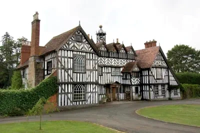 Historic England | |
| Nos 1 and 2 the Gatehouse About 50 Yards East of Westwood House | Westwood | Probably 1660–1670 | 1350205 |  Wikimedia Commons | |
| Ombersley Court | Ombersley | Francis Smith of Warwick | 1724–1732 | 1172877 |  Wikimedia Commons |
| Perrott House | Pershore | Possibly Robert Adam | c. 1760 | 1386920 |  Wikimedia Commons |
| Round House (National Westminster Bank) | Evesham | Late 15th century | 1156077 |  Wikimedia Commons | |
| The Almonry | Evesham | 15th century and earlier | 1302722 |  Wikimedia Commons | |
| The Bell Tower | Evesham | Early 16th century | 1081353 |  Wikimedia Commons | |
| The Tithe Barn | Middle Littleton | Early 14th century | 1319631 |  Wikimedia Commons | |
| Tithe Barn | Bredon | Late 14th century | 1319631 |  Wikimedia Commons | |
| Westwood House | Westwood | 1660–1670 | 1173950 | Wikimedia Commons |
See also
- Grade I listed buildings in Worcestershire
 Grade I listed buildings in the ceremonial county of Worcestershire, split into the six district authorities making up the county.
