

Winchester shown within Hampshire
Wikimedia Commons
Wikimedia Commons
The district authority of Winchester is one of the eleven district councils and two unitary authorities that make up the ceremonial county of Hampshire.[1]
The borough contains sixty-six of the Grade I listed buildings in Hampshire. Grade I structures are those considered to be “buildings of exceptional interest”.[2]
| Name | Location | Architect | Completed | Entry number | Image |
|---|---|---|---|---|---|
| 1, The Close | The Close | 1699 | 1095513 |  Wikimedia Commons | |
| 4, St Peter Street | St Peter Street | Sir C. Wren | 17th century | 1095390 |  Wikimedia Commons |
| 9, The Close | The Close | Early 17th centuty | 1350677 |  Wikimedia Commons | |
| 10, The Close | The Close | 18th century | 1095475 |  Wikimedia Commons | |
| 11, The Close | The Close | Mid to late 17th century | 1350678 |  Wikimedia Commons | |
| Avebury House | St Peter Street | 1690 | 1173668 | Wikimedia Commons | |
| Avington House | Avington | Late 16th century | 1095887 |  Wikimedia Commons | |
| Cart Shed to West of Hyde Abbey Gateway and adjoining it | King Alfred Place | Partly 12th century | 1296399 |  Wikimedia Commons | |
| Cathedral Church of the Holy Trinity | The Close | 1079–1095 | 1095509 |  Wikimedia Commons | |
| Chamber Court with Middle Gate, St Mary’s College | College Street | 14th century | 1296879 |  Wikimedia Commons | |
| Chapel, St Mary’s College | College Street | Late 14th century | 1350684 |  Wikimedia Commons | |
| Cheyney Court | The Close | 15th century | 1095517 |  Wikimedia Commons | |
| Church of All Saints | Bighton | 12th century | 1155172 |  Wikimedia Commons | |
| Church of Our Lady | Warnford | Saxon origin | 1296978 |  Wikimedia Commons | |
| Church of St Andrew | Chilcomb | c. 1120–1140 | 1095907 |  Wikimedia Commons | |
| Church of St Andrew | Titchborne | Mid-11th to 12th century | 1178485 |  Wikimedia Commons | |
| Church of St James Without the Priory Gate | Southwick and Widley | Pre 1150 | 1167160 |  Wikimedia Commons | |
| Church of St John | Hursley | 12th century | 1178648 |  Wikimedia Commons | |
| Church of St John the Baptist | St Johns Street | c. 1200 | 1296158 |  Wikimedia Commons | |
| Church of St Mary | Avington | 1768–1771 | 1350483 |  Wikimedia Commons | |
| Church of St Mary | Easton | c. 1200 | 1095898 |  Wikimedia Commons | |
| Church of St Mary and All Saints | Droxford | c. 1200 | 1095540 |  Wikimedia Commons | |
| Church of St Michael | Cheriton | 13th century | 1303010 |  Wikimedia Commons | |
| Church of St Michael | Wonston | c. 1190 | 1302427 |  Wikimedia Commons | |
| Church of St Nicholas | Bishops Sutton | 12th century | 1350825 |  Wikimedia Commons | |
| Church of St Peter | Soberton | Norman origin, but mainly 13th century | 1166968 |  Wikimedia Commons | |
| Church of St Peter and St Paul | Hambledon | 12th century | 1301325 |  Wikimedia Commons | |
| Church of St Swithun | Headbourne Worthy | Saxon, with later additions | 1350461 |  Wikimedia Commons | |
| City Bridge | HighStreet | 1813 | 1167781 |  Wikimedia Commons | |
| Cloisters St Mary’s College | College Street | Late 14th century | 1296887 |  Wikimedia Commons | |
| Close Boundary Walls and Gates, Priors Gate | The Close | 13th century | 1095512 |  Wikimedia Commons | |
| College Hall St Mary’s College | College Street | Late 14th century | 1095484 |  Wikimedia Commons | |
| Corhampton Church | Corhampton | c. 1020 | 1179686 |  Wikimedia Commons | |
| Cranbury House | Hursley | G. Dance Jnr. | 1790 | 1095809 |  Wikimedia Commons |
| Dome Alley | The Close | c. 1660 | 1095518 |  Wikimedia Commons | |
| Fort Nelson | Boarhunt | 1862–1872 | 1350616 |  Wikimedia Commons | |
| Fort Southwick | Southwick and Widley | 1860s | 1167213 |  Wikimedia Commons | |
| Fromond’s Chantry St Marys College | College Street | 15th century | 1095485 |  Wikimedia Commons | |
| Garden Wall to the South of Minster House on the East and South Sides of the Garden | Great Minster Street | 1833 | 1095459 |  Wikimedia Commons | |
| Godsfield Chapel adjacent to Godsfield Farmhouse | Old Alresford | Late 14th century | 1350808 | 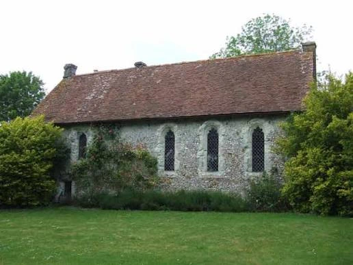 Historic England | |
| Great Hall Winchester Castle | Castle Avenue | 13th century | 1351065 |  Wikimedia Commons | |
| Hospital of St Cross and Almshouses of Noble Poverty | St Cross Road | 1136 | 1095374 |  Wikimedia Commons | |
| Hyde Abbey Gateway | King Alfred Place | 15th century | 1095419 |  Wikimedia Commons | |
| Kingsgate the Church of St Swithun Upon Kingsgate | St Swithun Street | 16th century | 1095355 |  Wikimedia Commons | |
| Marwell Hall | Owslebury | 14th century | 1350871 |  Wikimedia Commons | |
| Minster House | Great Minster Street | Early 18th century | 1350671 |  Wikimedia Commons | |
| New Place Shirrell Heath | Shirrel Heath | Lutyens | 1906 | 1095660 |  Wikimedia Commons |
| Outer Court With Outer Gate St Mary’s College | College Street | Late 14th century | 1095483 |  Wikimedia Commons | |
| Part of the City, Palace and Castle Wall Running East from Priory Gate to Angle near to Hall above Magdalen Hospital | Priory Gate | 13th century | 1095505 |  Wikimedia Commons | |
| Pilgrims’ Hall | The Close | 13th to 14th century | 1095516 |  Wikimedia Commons | |
| Pilgrims’ School | The Close | Late 17th to early 18th century | 1167387 |  Wikimedia Commons | |
| Porter’s Lodge | The Close | 15th century | 1296925 |  Wikimedia Commons | |
| School, Winchester College | College Street | 1687 | 1167544 |  Wikimedia Commons | |
| Sick House, St Mary’s College | College Street | 1656 | 1350685 |  Wikimedia Commons | |
| St John’s House | Warnford | 13th century | 1350308 |  Wikimedia Commons | |
| St John’s Rooms and Chapel | High Street | 13th century | 1095441 |  Wikimedia Commons | |
| St Mary’s College Warden’s Lodgings | College Street | Late 14th century | 1167489 |  Wikimedia Commons | |
| The Carnery | The Close | 14th century | 1350679 |  Wikimedia Commons | |
| The Deanery, Incorporating Prior’s Hall | The Close | 14th–15th century | 1095514 |  Wikimedia Commons | |
| The Grange | Northington | William Samwell | 1670–1673 | 1095216 |  Wikimedia Commons |
| The Judge’s Lodging | The Close | Late 17th/early 18th century | 1350657 |  Wikimedia Commons | |
| The Old Stables | The Close | Probably early 16th century | 1350656 |  Wikimedia Commons | |
| The War Cloister, Winchester College | College Street | Sir Herbert Baker | 1924 | 1095486 |  Wikimedia Commons |
| The Westgate | High Street | Mainly 13th and 14th century | 1350695 |  Wikimedia Commons | |
| Wolvesley Castle | The Close | 1129–1171 | 1095511 |  Wikimedia Commons | |
| Wolvesey Palace | Sir C. Wren | 1684 | 1095510 |  Wikimedia Commons |
See also
- Grade I listed buildings in Hampshire
 Grade I listed buildings in the ceremonial county of Hampshire.
